Rājgurunagar geodata
Rājgurunagar (Maharashtra) is a populated place; located in India in Asia/Kolkata (GMT+5.5) time zone. With population of 18,846 people, there are 2141 cities with bigger population in this country. Compared to other cities in India, 69% of cities are located further ↑North; 90.3% of cities are located further →East and 89.5% of cities have lower elevation than Rājgurunagar. Note1


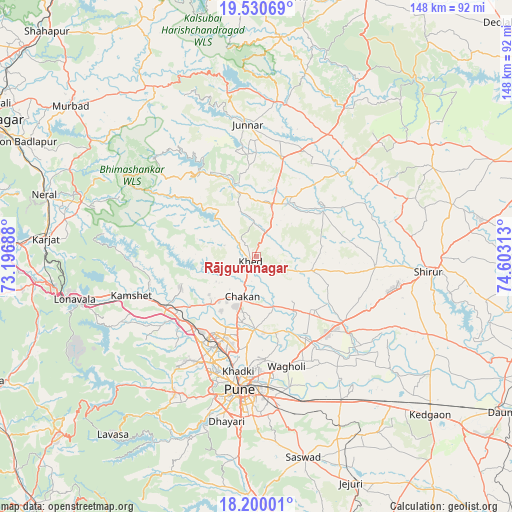
Rājgurunagar GPS coordinates[2]
18° 52' 0.012" North, 73° 54' 0" East
| Map corner | latitude | longitude |
|---|---|---|
| Upper-left | 19.53069°, | 73.19688° |
| Center: | 18.86667°, | 73.9° |
| Lower-right: | 18.20001°, | 74.60313° |
| Map W x H: | 148×148 km | = 92×92mi |
| max Lat: | 34.9274° ⇑69% North |
| Rājgurunagar: | 18.86667° |
| min Lat: | ⇓31% South 8.09008° |
| min Long | Rājgurunagar | max Long |
| 68.82655° | 73.9° | 96.81° |
| W 9.7%⇐ | ⇒90.3% E |
Elevation
Elevation of Rājgurunagar is 626 m = 2054 ft, and this is 330.4 m = 1084 ft above average elevation for this country.
| Max E: |
3681 m = 12077 ft | 10.5% |
| Rājgurunagar | 626 m 2054 ft | |
| Avg. | 295.6 m = 970 ft | |
Min E: |
1 m = 3 ft | 89.5% |
See also: India elevation on elevation.city.
Geographical zone
Rājgurunagar is located in North Torrid zone (between Equator and Tropic of Cancer). Distance of this Northern Tropic circle is 508.1 km =315.7 mi to North.| Distance of | km | miles | from Rājgurunagar |
|---|---|---|---|
| North Pole | 7909.3 | 4914.6 | to North |
| Arctic Circle | 5303.4 | 3295.4 | to North |
| Tropic Cancer | 508.1 | 315.7 | to North |
| Equator | 2097.8 | 1303.5 | to South |


Nearby cities:
15 places around Rājgurunagar: (largest is in red/bold)
• Alandi
21 km =13 mi,  180°
180°
• Chākan
12.4 km =7.7 mi,  198°
198°
• Dehu
21.7 km =13.5 mi,  220°
220°
• Junnar
38.1 km =23.7 mi,  356°
356°
• Kalamb
20.6 km =12.8 mi,  16°
16°
• Khadki
34.1 km =21.2 mi,  188°
188°
• Kharakvasla
49.2 km =30.6 mi, 195°
• Koregaon
29.7 km =18.5 mi,  145°
145°
• Lohogaon
29.9 km =18.6 mi,  174°
174°
• Manchar
16 km =9.9 mi, 16°
• Pimpri
28.8 km =17.9 mi, 199°
• Pune
38.9 km =24.2 mi, 186°
• Shivaji Nagar
37.7 km =23.4 mi, 187°
• Talegaon Dābhāde
27.8 km =17.3 mi,  238°
238°
• Wadgaon
30.9 km =19.2 mi, 242°
Sources, notices
• [Note1] Compared only with cities in India existing in our database
• [Src1] Map data: © OpenStreetMap contributors (CC-BY-SA)
• [Src2] Other city data from geonames.org with taken over terms of usage.
• [Src3] Geographical zone / Annual Mean Temperature by Robert A. Rohde @ Wikipedia
