Bhor geodata
Bhor (Maharashtra) is a populated place; located in India in Asia/Kolkata (GMT+5.5) time zone. With population of 18,982 people, there are 2127 cities with bigger population in this country. Compared to other cities in India, 71.4% of cities are located further ↑North; 90.7% of cities are located further →East and 89% of cities have lower elevation than Bhor. Note1


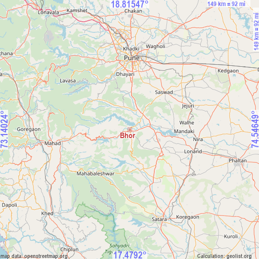
Bhor GPS coordinates[2]
18° 8' 54.996" North, 73° 50' 36.096" East
| Map corner | latitude | longitude |
|---|---|---|
| Upper-left | 18.81547°, | 73.14024° |
| Center: | 18.14861°, | 73.84336° |
| Lower-right: | 17.4792°, | 74.54649° |
| Map W x H: | 148.6×148.6 km | = 92.3×92.3mi |
| max Lat: | 34.9274° ⇑71.4% North |
| Bhor: | 18.14861° |
| min Lat: | ⇓28.6% South 8.09008° |
| min Long | Bhor | max Long |
| 68.82655° | 73.84336° | 96.81° |
| W 9.3%⇐ | ⇒90.7% E |
Elevation
Elevation of Bhor is 615 m = 2018 ft, and this is 319.4 m = 1048 ft above average elevation for this country.
| Max E: |
3681 m = 12077 ft | 11% |
| Bhor | 615 m 2018 ft | |
| Avg. | 295.6 m = 970 ft | |
Min E: |
1 m = 3 ft | 89% |
See also: India elevation on elevation.city.
Geographical zone
Bhor is located in North Torrid zone (between Equator and Tropic of Cancer). Distance of this Northern Tropic circle is 588 km =365.4 mi to North.| Distance of | km | miles | from Bhor |
|---|---|---|---|
| North Pole | 7989.1 | 4964.2 | to North |
| Arctic Circle | 5383.2 | 3345 | to North |
| Tropic Cancer | 588 | 365.4 | to North |
| Equator | 2017.9 | 1253.9 | to South |


Nearby cities:
15 places around Bhor: (largest is in red/bold)
• Goregaon
58.3 km =36.2 mi,  270°
270°
• Jejūri
36.4 km =22.6 mi,  66°
66°
• Khadki
46.1 km =28.6 mi,  1°
1°
• Kharakvasla
33.2 km =20.6 mi,  347°
347°
• Khed
21.1 km =13.1 mi, 0°
• Lohogaon
50.9 km =31.6 mi,  9°
9°
• Mahād
45.7 km =28.4 mi,  260°
260°
• Pimpri
52.9 km =32.9 mi,  355°
355°
• Pune
41.3 km =25.7 mi, 1°
• Pānchgani
25.3 km =15.7 mi,  190°
190°
• Satara
53.8 km =33.4 mi,  162°
162°
• Shirwal
14.2 km =8.8 mi,  89°
89°
• Shivaji Nagar
42.4 km =26.3 mi, 1°
• Sāsvad
29.4 km =18.3 mi,  42°
42°
• Wai
22.3 km =13.9 mi,  167°
167°
Sources, notices
• [Note1] Compared only with cities in India existing in our database
• [Src1] Map data: © OpenStreetMap contributors (CC-BY-SA)
• [Src2] Other city data from geonames.org with taken over terms of usage.
• [Src3] Geographical zone / Annual Mean Temperature by Robert A. Rohde @ Wikipedia
