Kudachi geodata
Kudachi (Karnataka) is a populated place; located in India in Asia/Kolkata (GMT+5.5) time zone. With population of 19,272 people, there are 2102 cities with bigger population in this country. Compared to other cities in India, 75.9% of cities are located further ↑North; 84% of cities are located further →East and 84.7% of cities have lower elevation than Kudachi. Note1


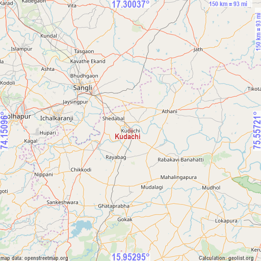
Kudachi GPS coordinates[2]
16° 37' 40.224" North, 74° 51' 14.688" East
| Map corner | latitude | longitude |
|---|---|---|
| Upper-left | 17.30037°, | 74.15096° |
| Center: | 16.62784°, | 74.85408° |
| Lower-right: | 15.95295°, | 75.55721° |
| Map W x H: | 149.8×149.8 km | = 93.1×93.1mi |
| max Lat: | 34.9274° ⇑75.9% North |
| Kudachi: | 16.62784° |
| min Lat: | ⇓24.1% South 8.09008° |
| min Long | Kudachi | max Long |
| 68.82655° | 74.85408° | 96.81° |
| W 16%⇐ | ⇒84% E |
Elevation
Elevation of Kudachi is 547 m = 1795 ft, and this is 251.4 m = 825 ft above average elevation for this country.
| Max E: |
3681 m = 12077 ft | 15.3% |
| Kudachi | 547 m 1795 ft | |
| Avg. | 295.6 m = 970 ft | |
Min E: |
1 m = 3 ft | 84.7% |
See also: India elevation on elevation.city.
Geographical zone
Kudachi is located in North Torrid zone (between Equator and Tropic of Cancer). Distance of this Northern Tropic circle is 757.1 km =470.4 mi to North.| Distance of | km | miles | from Kudachi |
|---|---|---|---|
| North Pole | 8158.2 | 5069.3 | to North |
| Arctic Circle | 5552.3 | 3450 | to North |
| Tropic Cancer | 757.1 | 470.4 | to North |
| Equator | 1848.8 | 1148.8 | to South |


Nearby cities:
15 places around Kudachi: (largest is in red/bold)
• Athni
24.9 km =15.5 mi,  63°
63°
• Bhudgaon
41.2 km =25.6 mi,  318°
318°
• Chikodi
36.1 km =22.4 mi,  232°
232°
• Ichalkaranji
42.5 km =26.4 mi,  279°
279°
• Jaisingpur
36 km =22.4 mi,  297°
297°
• Jamkhandi
48.6 km =30.2 mi,  106°
106°
• Konnūr
48.7 km =30.3 mi,  193°
193°
• Kurandvād
28.9 km =18 mi, 282°
• Mahālingpur
38 km =23.6 mi,  134°
134°
• Rabkavi
32.2 km =20 mi,  121°
121°
• Rāybāg
17.4 km =10.8 mi,  209°
209°
• Sadalgi
35.2 km =21.9 mi,  257°
257°
• Shiraguppi
15.5 km =9.6 mi,  266°
266°
• Sāngli
39.8 km =24.7 mi,  309°
309°
• Terdāl
25.4 km =15.8 mi, 125°
Sources, notices
• [Note1] Compared only with cities in India existing in our database
• [Src1] Map data: © OpenStreetMap contributors (CC-BY-SA)
• [Src2] Other city data from geonames.org with taken over terms of usage.
• [Src3] Geographical zone / Annual Mean Temperature by Robert A. Rohde @ Wikipedia
