Athni geodata
Athni (Karnataka) is a populated place; located in India in Asia/Kolkata (GMT+5.5) time zone. With population of 42,047 people, there are 1052 cities with bigger population in this country. Compared to other cities in India, 75.6% of cities are located further ↑North; 82.2% of cities are located further →East and 86.8% of cities have lower elevation than Athni. Note1


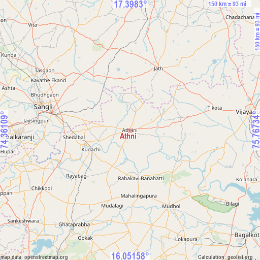
Athni GPS coordinates[2]
16° 43' 34.068" North, 75° 3' 51.156" East
| Map corner | latitude | longitude |
|---|---|---|
| Upper-left | 17.3983°, | 74.36109° |
| Center: | 16.72613°, | 75.06421° |
| Lower-right: | 16.05158°, | 75.76734° |
| Map W x H: | 149.7×149.7 km | = 93×93mi |
| max Lat: | 34.9274° ⇑75.6% North |
| Athni: | 16.72613° |
| min Lat: | ⇓24.4% South 8.09008° |
| min Long | Athni | max Long |
| 68.82655° | 75.06421° | 96.81° |
| W 17.8%⇐ | ⇒82.2% E |
Elevation
Elevation of Athni is 573 m = 1880 ft, and this is 277.4 m = 910 ft above average elevation for this country.
| Max E: |
3681 m = 12077 ft | 13.2% |
| Athni | 573 m 1880 ft | |
| Avg. | 295.6 m = 970 ft | |
Min E: |
1 m = 3 ft | 86.8% |
See also: Athni elevation on elevation.city.
Geographical zone
Athni is located in North Torrid zone (between Equator and Tropic of Cancer). Distance of this Northern Tropic circle is 746.1 km =463.6 mi to North.| Distance of | km | miles | from Athni |
|---|---|---|---|
| North Pole | 8147.3 | 5062.5 | to North |
| Arctic Circle | 5541.4 | 3443.3 | to North |
| Tropic Cancer | 746.1 | 463.6 | to North |
| Equator | 1859.8 | 1155.6 | to South |


Nearby cities:
15 places around Athni: (largest is in red/bold)
• Bhudgaon
53.4 km =33.2 mi,  292°
292°
• Chikodi
60.7 km =37.7 mi,  237°
237°
• Jaisingpur
54.7 km =34 mi,  275°
275°
• Jamkhandi
34.5 km =21.4 mi,  135°
135°
• Kudachi
24.9 km =15.5 mi, 243°
• Kurandvād
50.8 km =31.6 mi,  264°
264°
• Mahālingpur
37.8 km =23.5 mi,  172°
172°
• Mudhol
49.5 km =30.8 mi,  151°
151°
• Rabkavi
28.3 km =17.6 mi, 169°
• Rāybāg
40.4 km =25.1 mi,  229°
229°
• Sadalgi
59.7 km =37.1 mi,  251°
251°
• Shiraguppi
39.7 km =24.7 mi, 252°
• Sāngli
55.1 km =34.2 mi, 284°
• Terdāl
25.9 km =16.1 mi,  184°
184°
• Tāsgaon
60.1 km =37.3 mi,  305°
305°
Sources, notices
• [Note1] Compared only with cities in India existing in our database
• [Src1] Map data: © OpenStreetMap contributors (CC-BY-SA)
• [Src2] Other city data from geonames.org with taken over terms of usage.
• [Src3] Geographical zone / Annual Mean Temperature by Robert A. Rohde @ Wikipedia
