Rāybāg geodata
Rāybāg (Karnataka) is a populated place; located in India in Asia/Kolkata (GMT+5.5) time zone. With population of 17,389 people, there are 2247 cities with bigger population in this country. Compared to other cities in India, 76.5% of cities are located further ↑North; 84.6% of cities are located further →East and 87.4% of cities have lower elevation than Rāybāg. Note1


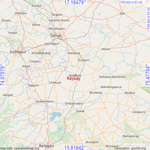
Rāybāg GPS coordinates[2]
16° 29' 30.408" North, 74° 46' 26.076" East
| Map corner | latitude | longitude |
|---|---|---|
| Upper-left | 17.16479°, | 74.07079° |
| Center: | 16.49178°, | 74.77391° |
| Lower-right: | 15.81642°, | 75.47704° |
| Map W x H: | 149.9×149.9 km | = 93.1×93.1mi |
| max Lat: | 34.9274° ⇑76.5% North |
| Rāybāg: | 16.49178° |
| min Lat: | ⇓23.5% South 8.09008° |
| min Long | Rāybāg | max Long |
| 68.82655° | 74.77391° | 96.81° |
| W 15.4%⇐ | ⇒84.6% E |
Elevation
Elevation of Rāybāg is 585 m = 1919 ft, and this is 289.4 m = 949 ft above average elevation for this country.
| Max E: |
3681 m = 12077 ft | 12.6% |
| Rāybāg | 585 m 1919 ft | |
| Avg. | 295.6 m = 970 ft | |
Min E: |
1 m = 3 ft | 87.4% |
See also: India elevation on elevation.city.
Geographical zone
Rāybāg is located in North Torrid zone (between Equator and Tropic of Cancer). Distance of this Northern Tropic circle is 772.2 km =479.8 mi to North.| Distance of | km | miles | from Rāybāg |
|---|---|---|---|
| North Pole | 8173.3 | 5078.7 | to North |
| Arctic Circle | 5567.5 | 3459.5 | to North |
| Tropic Cancer | 772.2 | 479.8 | to North |
| Equator | 1833.7 | 1139.4 | to South |


Nearby cities:
15 places around Rāybāg: (largest is in red/bold)
• Athni
40.4 km =25.1 mi,  49°
49°
• Chikodi
21.2 km =13.2 mi,  250°
250°
• Gokak
36.3 km =22.6 mi,  171°
171°
• Hukeri
34.3 km =21.3 mi,  212°
212°
• Ichalkaranji
40.1 km =24.9 mi,  303°
303°
• Jaisingpur
39.4 km =24.5 mi,  323°
323°
• Konnūr
32.4 km =20.1 mi,  184°
184°
• Kudachi
17.4 km =10.8 mi,  29°
29°
• Kurandvād
29 km =18 mi, 317°
• Mahālingpur
37.5 km =23.3 mi,  107°
107°
• Rabkavi
35.9 km =22.3 mi,  92°
92°
• Sadalgi
26.8 km =16.7 mi,  286°
286°
• Sankeshwar
40.7 km =25.3 mi,  229°
229°
• Shiraguppi
15.7 km =9.8 mi,  333°
333°
• Terdāl
29.1 km =18.1 mi, 89°
Sources, notices
• [Note1] Compared only with cities in India existing in our database
• [Src1] Map data: © OpenStreetMap contributors (CC-BY-SA)
• [Src2] Other city data from geonames.org with taken over terms of usage.
• [Src3] Geographical zone / Annual Mean Temperature by Robert A. Rohde @ Wikipedia
