Kunnumma geodata
Kunnumma (Kerala) is a populated place; located in India in Asia/Kolkata (GMT+5.5) time zone. With population of 14,918 people, there are 2472 cities with bigger population in this country. Compared to other cities in India, 98% of cities are located further ↑North; 69% of cities are located further →East and 99% of cities have higher elevation than Kunnumma. Note1


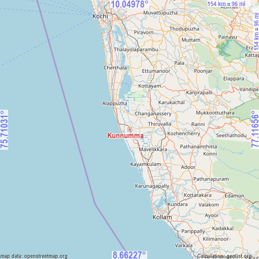
Kunnumma GPS coordinates[2]
9° 21' 24.192" North, 76° 24' 48.348" East
| Map corner | latitude | longitude |
|---|---|---|
| Upper-left | 10.04978°, | 75.71031° |
| Center: | 9.35672°, | 76.41343° |
| Lower-right: | 8.66227°, | 77.11656° |
| Map W x H: | 154.3×154.3 km | = 95.9×95.9mi |
| max Lat: | 34.9274° ⇑98% North |
| Kunnumma: | 9.35672° |
| min Lat: | ⇓2% South 8.09008° |
| min Long | Kunnumma | max Long |
| 68.82655° | 76.41343° | 96.81° |
| W 31%⇐ | ⇒69% E |
Elevation
Elevation of Kunnumma is 7 m = 23 ft, and this is 288.6 m = 947 ft below average elevation for this country.
| Max E: |
3681 m = 12077 ft | 99% |
| Avg. | 295.6 m = 970 ft | |
| Kunnumma | 7 m = 23 ft | |
Min E: |
1 m = 3 ft | 1% |
See also: India elevation on elevation.city.
Geographical zone
Kunnumma is located in North Torrid zone (between Equator and Tropic of Cancer). Distance of Equator is 1040.4 km =646.5 mi to South.| Distance of | km | miles | from Kunnumma |
|---|---|---|---|
| North Pole | 8966.7 | 5571.6 | to North |
| Arctic Circle | 6360.8 | 3952.4 | to North |
| Tropic Cancer | 1565.5 | 972.8 | to North |
| Equator | 1040.4 | 646.5 | to South |


Nearby cities:
15 places around Kunnumma: (largest is in red/bold)
• Adūr
41.5 km =25.8 mi,  122°
122°
• Alappuzha
17.6 km =10.9 mi,  327°
327°
• Changanācheri
16.5 km =10.3 mi,  54°
54°
• Chengannūr
22.6 km =14 mi,  101°
101°
• Cherthala
37.4 km =23.2 mi,  346°
346°
• Kalavoor
25.6 km =15.9 mi,  338°
338°
• Kattanam
26 km =16.2 mi,  140°
140°
• Kottayam
28.2 km =17.5 mi,  24°
24°
• Kāyankulam
21.7 km =13.5 mi,  153°
153°
• Māvelikara
19.1 km =11.9 mi, 124°
• Pathanāmthitta
41.8 km =26 mi, 103°
• Ponmana
40.5 km =25.2 mi,  163°
163°
• Shertallai
37.5 km =23.3 mi, 347°
• Tiruvalla
17.9 km =11.1 mi,  81°
81°
• Vayalār
40.3 km =25 mi, 348°
Sources, notices
• [Note1] Compared only with cities in India existing in our database
• [Src1] Map data: © OpenStreetMap contributors (CC-BY-SA)
• [Src2] Other city data from geonames.org with taken over terms of usage.
• [Src3] Geographical zone / Annual Mean Temperature by Robert A. Rohde @ Wikipedia
