Chengannūr geodata
Chengannūr (Kerala) is a populated place; located in India in Asia/Kolkata (GMT+5.5) time zone. With population of 25,043 people, there are 1697 cities with bigger population in this country. Compared to other cities in India, 98.1% of cities are located further ↑North; 67.1% of cities are located further →East and 92.8% of cities have higher elevation than Chengannūr. Note1


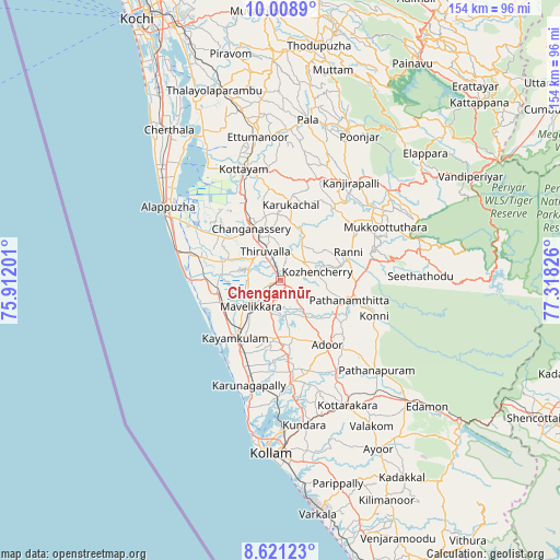
Chengannūr GPS coordinates[2]
9° 18' 56.7" North, 76° 36' 54.468" East
| Map corner | latitude | longitude |
|---|---|---|
| Upper-left | 10.0089°, | 75.91201° |
| Center: | 9.31575°, | 76.61513° |
| Lower-right: | 8.62123°, | 77.31826° |
| Map W x H: | 154.3×154.3 km | = 95.9×95.9mi |
| max Lat: | 34.9274° ⇑98.1% North |
| Chengannūr: | 9.31575° |
| min Lat: | ⇓1.9% South 8.09008° |
| min Long | Chengannūr | max Long |
| 68.82655° | 76.61513° | 96.81° |
| W 32.9%⇐ | ⇒67.1% E |
Elevation
Elevation of Chengannūr is 14 m = 46 ft, and this is 281.6 m = 924 ft below average elevation for this country.
| Max E: |
3681 m = 12077 ft | 92.8% |
| Avg. | 295.6 m = 970 ft | |
| Chengannūr | 14 m = 46 ft | |
Min E: |
1 m = 3 ft | 7.2% |
See also: India elevation on elevation.city.
Geographical zone
Chengannūr is located in North Torrid zone (between Equator and Tropic of Cancer). Distance of Equator is 1035.8 km =643.6 mi to South.| Distance of | km | miles | from Chengannūr |
|---|---|---|---|
| North Pole | 8971.2 | 5574.4 | to North |
| Arctic Circle | 6365.4 | 3955.3 | to North |
| Tropic Cancer | 1570.1 | 975.6 | to North |
| Equator | 1035.8 | 643.6 | to South |


Nearby cities:
15 places around Chengannūr: (largest is in red/bold)
• Adūr
21.9 km =13.6 mi,  144°
144°
• Alappuzha
37.1 km =23.1 mi,  301°
301°
• Changanācheri
16.5 km =10.3 mi,  328°
328°
• Erāttupetta
45.1 km =28 mi,  23°
23°
• Kalavoor
42.4 km =26.3 mi,  311°
311°
• Kattanam
16.5 km =10.3 mi,  200°
200°
• Kottayam
31.9 km =19.8 mi,  341°
341°
• Kunnumma
22.6 km =14 mi,  281°
281°
• Kāyankulam
19.5 km =12.1 mi,  220°
220°
• Lālam
45.5 km =28.3 mi,  11°
11°
• Māvelikara
9 km =5.6 mi,  225°
225°
• Pathanāmthitta
19.2 km =11.9 mi,  106°
106°
• Ponmana
35.8 km =22.2 mi, 196°
• Punalūr
47.2 km =29.3 mi,  134°
134°
• Tiruvalla
8.5 km =5.3 mi, 328°
Sources, notices
• [Note1] Compared only with cities in India existing in our database
• [Src1] Map data: © OpenStreetMap contributors (CC-BY-SA)
• [Src2] Other city data from geonames.org with taken over terms of usage.
• [Src3] Geographical zone / Annual Mean Temperature by Robert A. Rohde @ Wikipedia
