Kattanam geodata
Kattanam (Kerala) is a populated place; located in India in Asia/Kolkata (GMT+5.5) time zone. With population of 19,764 people, there are 2057 cities with bigger population in this country. Compared to other cities in India, 98.5% of cities are located further ↑North; 67.8% of cities are located further →East and 88.1% of cities have higher elevation than Kattanam. Note1


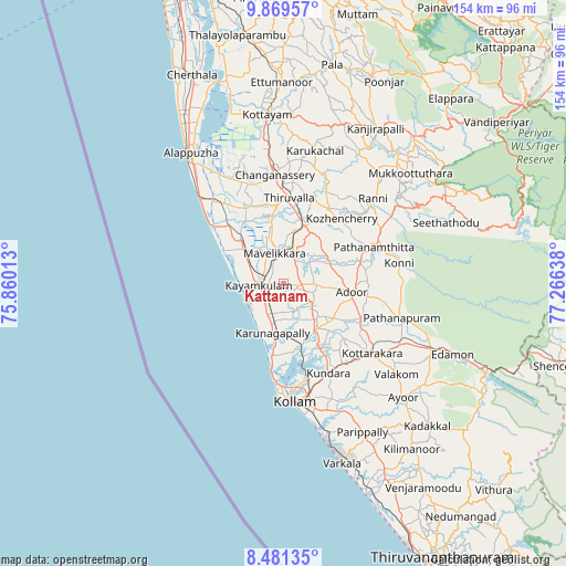
Kattanam GPS coordinates[2]
9° 10' 34.104" North, 76° 33' 47.7" East
| Map corner | latitude | longitude |
|---|---|---|
| Upper-left | 9.86957°, | 75.86013° |
| Center: | 9.17614°, | 76.56325° |
| Lower-right: | 8.48135°, | 77.26638° |
| Map W x H: | 154.4×154.4 km | = 95.9×95.9mi |
| max Lat: | 34.9274° ⇑98.5% North |
| Kattanam: | 9.17614° |
| min Lat: | ⇓1.5% South 8.09008° |
| min Long | Kattanam | max Long |
| 68.82655° | 76.56325° | 96.81° |
| W 32.2%⇐ | ⇒67.8% E |
Elevation
Elevation of Kattanam is 22 m = 72 ft, and this is 273.6 m = 898 ft below average elevation for this country.
| Max E: |
3681 m = 12077 ft | 88.1% |
| Avg. | 295.6 m = 970 ft | |
| Kattanam | 22 m = 72 ft | |
Min E: |
1 m = 3 ft | 11.9% |
See also: India elevation on elevation.city.
Geographical zone
Kattanam is located in North Torrid zone (between Equator and Tropic of Cancer). Distance of Equator is 1020.3 km =634 mi to South.| Distance of | km | miles | from Kattanam |
|---|---|---|---|
| North Pole | 8986.8 | 5584.1 | to North |
| Arctic Circle | 6380.9 | 3964.9 | to North |
| Tropic Cancer | 1585.6 | 985.2 | to North |
| Equator | 1020.3 | 634 | to South |


Nearby cities:
15 places around Kattanam: (largest is in red/bold)
• Adūr
18.7 km =11.6 mi,  96°
96°
• Alappuzha
43.5 km =27 mi,  323°
323°
• Changanācheri
29.7 km =18.5 mi,  354°
354°
• Chengannūr
16.5 km =10.3 mi,  20°
20°
• Kalavoor
50.9 km =31.6 mi,  329°
329°
• Kollam
32.9 km =20.4 mi,  175°
175°
• Kottayam
45.9 km =28.5 mi, 354°
• Kunnumma
26 km =16.2 mi, 320°
• Kāyankulam
6.9 km =4.3 mi,  275°
275°
• Māvelikara
9.3 km =5.8 mi,  355°
355°
• Paravūr Tekkumbhāgam
43.9 km =27.3 mi,  164°
164°
• Pathanāmthitta
26.2 km =16.3 mi,  67°
67°
• Ponmana
19.3 km =12 mi,  194°
194°
• Punalūr
43.1 km =26.8 mi,  113°
113°
• Tiruvalla
22.9 km =14.2 mi,  3°
3°
Sources, notices
• [Note1] Compared only with cities in India existing in our database
• [Src1] Map data: © OpenStreetMap contributors (CC-BY-SA)
• [Src2] Other city data from geonames.org with taken over terms of usage.
• [Src3] Geographical zone / Annual Mean Temperature by Robert A. Rohde @ Wikipedia
