Yanam geodata
Yanam (Andhra Pradesh) is a populated place; located in India in Asia/Kolkata (GMT+5.5) time zone. With population of 36,896 people, there are 1188 cities with bigger population in this country. Compared to other cities in India, 75.6% of cities are located further ↑North; 77.4% of cities are located further ←West and 95.4% of cities have higher elevation than Yanam. Note1


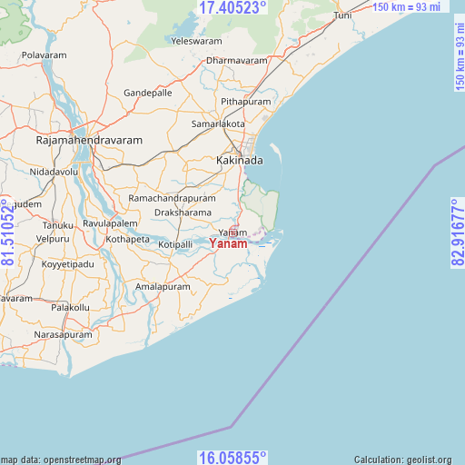
Yanam GPS coordinates[2]
16° 43' 59.088" North, 82° 12' 49.104" East
| Map corner | latitude | longitude |
|---|---|---|
| Upper-left | 17.40523°, | 81.51052° |
| Center: | 16.73308°, | 82.21364° |
| Lower-right: | 16.05855°, | 82.91677° |
| Map W x H: | 149.7×149.7 km | = 93×93mi |
| max Lat: | 34.9274° ⇑75.6% North |
| Yanam: | 16.73308° |
| min Lat: | ⇓24.4% South 8.09008° |
| min Long | Yanam | max Long |
| 68.82655° | 82.21364° | 96.81° |
| W 77.4%⇐ | ⇒22.6% E |
Elevation
Elevation of Yanam is 11 m = 36 ft, and this is 284.6 m = 934 ft below average elevation for this country.
| Max E: |
3681 m = 12077 ft | 95.4% |
| Avg. | 295.6 m = 970 ft | |
| Yanam | 11 m = 36 ft | |
Min E: |
1 m = 3 ft | 4.6% |
See also: India elevation on elevation.city.
Geographical zone
Yanam is located in North Torrid zone (between Equator and Tropic of Cancer). Distance of this Northern Tropic circle is 745.4 km =463.2 mi to North.| Distance of | km | miles | from Yanam |
|---|---|---|---|
| North Pole | 8146.5 | 5062 | to North |
| Arctic Circle | 5540.6 | 3442.8 | to North |
| Tropic Cancer | 745.4 | 463.2 | to North |
| Equator | 1860.5 | 1156.1 | to South |


Nearby cities:
15 places around Yanam: (largest is in red/bold)
• Amalāpuram
28 km =17.4 mi,  232°
232°
• Kovvūr
60.4 km =37.5 mi,  301°
301°
• Kākināda
25.4 km =15.8 mi,  5°
5°
• Mandapeta
33.5 km =20.8 mi, 295°
• Peddāpuram
39.1 km =24.3 mi,  348°
348°
• Penugonda
50.6 km =31.4 mi,  259°
259°
• Pithāpuram
42.9 km =26.7 mi, 5°
• Pālakollu
56.9 km =35.4 mi,  244°
244°
• Ramanayyapeta
23.7 km =14.7 mi, 6°
• Rājahmundry
55.4 km =34.4 mi, 303°
• Rāmachandrapuram
22.8 km =14.2 mi, 300°
• Rāzole
49.1 km =30.5 mi, 234°
• Sāmalkot
36.2 km =22.5 mi, 353°
• Tanuku
56.7 km =35.2 mi,  272°
272°
• vadlamuru
40.6 km =25.2 mi, 352°
Sources, notices
• [Note1] Compared only with cities in India existing in our database
• [Src1] Map data: © OpenStreetMap contributors (CC-BY-SA)
• [Src2] Other city data from geonames.org with taken over terms of usage.
• [Src3] Geographical zone / Annual Mean Temperature by Robert A. Rohde @ Wikipedia
