Kākināda geodata
Kākināda (Andhra Pradesh) is a populated place; located in India in Asia/Kolkata (GMT+5.5) time zone. With population of 292,923 people, there are 151 cities with bigger population in this country. Compared to other cities in India, 74.9% of cities are located further ↑North; 77.4% of cities are located further ←West and 99.4% of cities have higher elevation than Kākināda. Note1


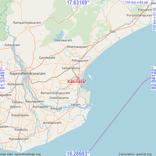
Kākināda GPS coordinates[2]
16° 57' 37.296" North, 82° 14' 17.124" East
| Map corner | latitude | longitude |
|---|---|---|
| Upper-left | 17.63169°, | 81.53497° |
| Center: | 16.96036°, | 82.23809° |
| Lower-right: | 16.28663°, | 82.94122° |
| Map W x H: | 149.6×149.6 km | = 93×93mi |
| max Lat: | 34.9274° ⇑74.9% North |
| Kākināda: | 16.96036° |
| min Lat: | ⇓25.1% South 8.09008° |
| min Long | Kākināda | max Long |
| 68.82655° | 82.23809° | 96.81° |
| W 77.4%⇐ | ⇒22.6% E |
Elevation
Elevation of Kākināda is 6 m = 20 ft, and this is 289.6 m = 950 ft below average elevation for this country.
| Max E: |
3681 m = 12077 ft | 99.4% |
| Avg. | 295.6 m = 970 ft | |
| Kākināda | 6 m = 20 ft | |
Min E: |
1 m = 3 ft | 0.6% |
See also: Kākināda elevation on elevation.city.
Geographical zone
Kākināda is located in North Torrid zone (between Equator and Tropic of Cancer). Distance of this Northern Tropic circle is 720.1 km =447.4 mi to North.| Distance of | km | miles | from Kākināda |
|---|---|---|---|
| North Pole | 8121.2 | 5046.3 | to North |
| Arctic Circle | 5515.4 | 3427.1 | to North |
| Tropic Cancer | 720.1 | 447.4 | to North |
| Equator | 1885.8 | 1171.8 | to South |


Nearby cities:
15 places around Kākināda: (largest is in red/bold)
• Amalāpuram
49.1 km =30.5 mi,  210°
210°
• Gokavaram
52.9 km =32.9 mi,  308°
308°
• Kovvūr
54.5 km =33.9 mi,  276°
276°
• Mandapeta
34.6 km =21.5 mi,  251°
251°
• Nidadavole
60.5 km =37.6 mi,  264°
264°
• Peddāpuram
16.8 km =10.4 mi,  320°
320°
• Penugonda
62.5 km =38.8 mi,  236°
236°
• Pithāpuram
17.5 km =10.9 mi,  5°
5°
• Ramanayyapeta
1.7 km =1.1 mi,  178°
178°
• Rājahmundry
49.2 km =30.6 mi, 275°
• Rāmachandrapuram
26.2 km =16.3 mi, 238°
• Sāmalkot
12.6 km =7.8 mi,  328°
328°
• Tuni
55.1 km =34.2 mi,  36°
36°
• Yanam
25.4 km =15.8 mi,  185°
185°
• vadlamuru
16.9 km =10.5 mi, 332°
Sources, notices
• [Note1] Compared only with cities in India existing in our database
• [Src1] Map data: © OpenStreetMap contributors (CC-BY-SA)
• [Src2] Other city data from geonames.org with taken over terms of usage.
• [Src3] Geographical zone / Annual Mean Temperature by Robert A. Rohde @ Wikipedia
