Rājahmundry geodata
Rājahmundry (Andhra Pradesh) is a populated place; located in India in Asia/Kolkata (GMT+5.5) time zone. With population of 304,804 people, there are 143 cities with bigger population in this country. Compared to other cities in India, 74.8% of cities are located further ↑North; 75.9% of cities are located further ←West and 83.9% of cities have higher elevation than Rājahmundry. Note1


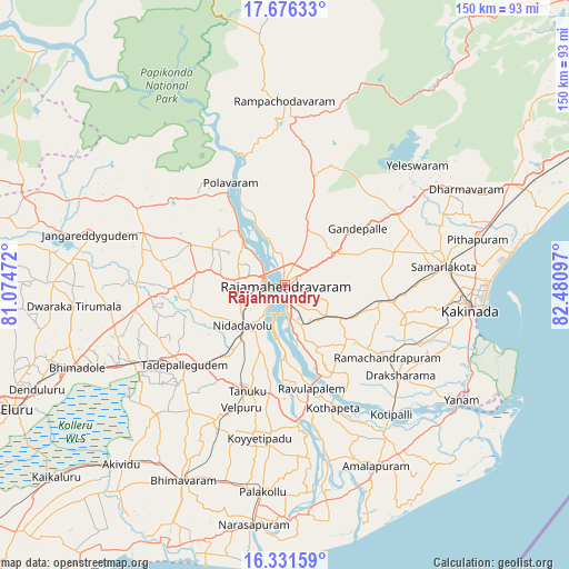
Rājahmundry GPS coordinates[2]
17° 0' 18.612" North, 81° 46' 40.224" East
| Map corner | latitude | longitude |
|---|---|---|
| Upper-left | 17.67633°, | 81.07472° |
| Center: | 17.00517°, | 81.77784° |
| Lower-right: | 16.33159°, | 82.48097° |
| Map W x H: | 149.5×149.5 km | = 92.9×92.9mi |
| max Lat: | 34.9274° ⇑74.8% North |
| Rājahmundry: | 17.00517° |
| min Lat: | ⇓25.2% South 8.09008° |
| min Long | Rājahmundry | max Long |
| 68.82655° | 81.77784° | 96.81° |
| W 75.9%⇐ | ⇒24.1% E |
Elevation
Elevation of Rājahmundry is 34 m = 112 ft, and this is 261.6 m = 858 ft below average elevation for this country.
| Max E: |
3681 m = 12077 ft | 83.9% |
| Avg. | 295.6 m = 970 ft | |
| Rājahmundry | 34 m = 112 ft | |
Min E: |
1 m = 3 ft | 16.1% |
See also: Rājahmundry elevation on elevation.city.
Geographical zone
Rājahmundry is located in North Torrid zone (between Equator and Tropic of Cancer). Distance of this Northern Tropic circle is 715.1 km =444.3 mi to North.| Distance of | km | miles | from Rājahmundry |
|---|---|---|---|
| North Pole | 8116.3 | 5043.2 | to North |
| Arctic Circle | 5510.4 | 3424 | to North |
| Tropic Cancer | 715.1 | 444.3 | to North |
| Equator | 1890.8 | 1174.9 | to South |


Nearby cities:
15 places around Rājahmundry: (largest is in red/bold)
• Attili
38.9 km =24.2 mi,  209°
209°
• Gokavaram
29.2 km =18.1 mi,  15°
15°
• Kovvūr
5.3 km =3.3 mi,  283°
283°
• Mandapeta
22.6 km =14 mi,  134°
134°
• Nidadavole
15.8 km =9.8 mi,  225°
225°
• Peddāpuram
39.1 km =24.3 mi,  78°
78°
• Penugonda
39.2 km =24.4 mi,  185°
185°
• Pippara
40.2 km =25 mi,  217°
217°
• Polavaram
30.5 km =19 mi,  332°
332°
• Rampachodavaram
48.4 km =30.1 mi,  359°
359°
• Rāmachandrapuram
32.6 km =20.3 mi, 125°
• Sāmalkot
42.8 km =26.6 mi, 82°
• Tanuku
29.7 km =18.5 mi,  200°
200°
• Tādepallegūdem
34.1 km =21.2 mi, 231°
• vadlamuru
42.4 km =26.3 mi, 76°
Sources, notices
• [Note1] Compared only with cities in India existing in our database
• [Src1] Map data: © OpenStreetMap contributors (CC-BY-SA)
• [Src2] Other city data from geonames.org with taken over terms of usage.
• [Src3] Geographical zone / Annual Mean Temperature by Robert A. Rohde @ Wikipedia
