Kovvūr geodata
Kovvūr (Andhra Pradesh) is a populated place; located in India in Asia/Kolkata (GMT+5.5) time zone. With population of 40,379 people, there are 1091 cities with bigger population in this country. Compared to other cities in India, 74.7% of cities are located further ↑North; 75.7% of cities are located further ←West and 87.6% of cities have higher elevation than Kovvūr. Note1


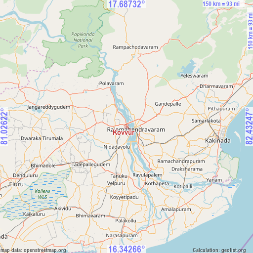
Kovvūr GPS coordinates[2]
17° 0' 58.32" North, 81° 43' 45.624" East
| Map corner | latitude | longitude |
|---|---|---|
| Upper-left | 17.68732°, | 81.02622° |
| Center: | 17.0162°, | 81.72934° |
| Lower-right: | 16.34266°, | 82.43247° |
| Map W x H: | 149.5×149.5 km | = 92.9×92.9mi |
| max Lat: | 34.9274° ⇑74.7% North |
| Kovvūr: | 17.0162° |
| min Lat: | ⇓25.3% South 8.09008° |
| min Long | Kovvūr | max Long |
| 68.82655° | 81.72934° | 96.81° |
| W 75.7%⇐ | ⇒24.3% E |
Elevation
Elevation of Kovvūr is 23 m = 75 ft, and this is 272.6 m = 894 ft below average elevation for this country.
| Max E: |
3681 m = 12077 ft | 87.6% |
| Avg. | 295.6 m = 970 ft | |
| Kovvūr | 23 m = 75 ft | |
Min E: |
1 m = 3 ft | 12.4% |
See also: Kovvūr elevation on elevation.city.
Geographical zone
Kovvūr is located in North Torrid zone (between Equator and Tropic of Cancer). Distance of this Northern Tropic circle is 713.9 km =443.6 mi to North.| Distance of | km | miles | from Kovvūr |
|---|---|---|---|
| North Pole | 8115 | 5042.4 | to North |
| Arctic Circle | 5509.1 | 3423.2 | to North |
| Tropic Cancer | 713.9 | 443.6 | to North |
| Equator | 1892 | 1175.6 | to South |


Nearby cities:
15 places around Kovvūr: (largest is in red/bold)
• Attili
37.8 km =23.5 mi,  201°
201°
• Gokavaram
29.8 km =18.5 mi,  25°
25°
• Mandapeta
27.3 km =17 mi,  128°
128°
• Nidadavole
13.7 km =8.5 mi,  206°
206°
• Peddāpuram
44 km =27.3 mi,  81°
81°
• Penugonda
40.4 km =25.1 mi,  177°
177°
• Pippara
38.4 km =23.9 mi, 209°
• Polavaram
27.3 km =17 mi,  340°
340°
• Rampachodavaram
47.5 km =29.5 mi,  5°
5°
• Rājahmundry
5.3 km =3.3 mi,  103°
103°
• Rāmachandrapuram
37.6 km =23.4 mi,  122°
122°
• Sāmalkot
47.7 km =29.6 mi, 84°
• Tanuku
29.6 km =18.4 mi,  189°
189°
• Tādepallegūdem
31.1 km =19.3 mi,  223°
223°
• vadlamuru
47.2 km =29.3 mi, 79°
Sources, notices
• [Note1] Compared only with cities in India existing in our database
• [Src1] Map data: © OpenStreetMap contributors (CC-BY-SA)
• [Src2] Other city data from geonames.org with taken over terms of usage.
• [Src3] Geographical zone / Annual Mean Temperature by Robert A. Rohde @ Wikipedia
