Mandapeta geodata
Mandapeta (Andhra Pradesh) is a populated place; located in India in Asia/Kolkata (GMT+5.5) time zone. With population of 48,852 people, there are 904 cities with bigger population in this country. Compared to other cities in India, 75.2% of cities are located further ↑North; 76.3% of cities are located further ←West and 90.4% of cities have higher elevation than Mandapeta. Note1


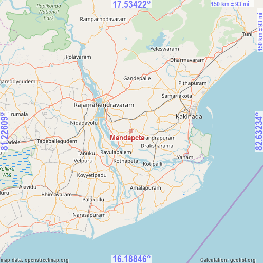
Mandapeta GPS coordinates[2]
16° 51' 45.144" North, 81° 55' 45.156" East
| Map corner | latitude | longitude |
|---|---|---|
| Upper-left | 17.53422°, | 81.22609° |
| Center: | 16.86254°, | 81.92921° |
| Lower-right: | 16.18846°, | 82.63234° |
| Map W x H: | 149.6×149.6 km | = 93×93mi |
| max Lat: | 34.9274° ⇑75.2% North |
| Mandapeta: | 16.86254° |
| min Lat: | ⇓24.8% South 8.09008° |
| min Long | Mandapeta | max Long |
| 68.82655° | 81.92921° | 96.81° |
| W 76.3%⇐ | ⇒23.7% E |
Elevation
Elevation of Mandapeta is 17 m = 56 ft, and this is 278.6 m = 914 ft below average elevation for this country.
| Max E: |
3681 m = 12077 ft | 90.4% |
| Avg. | 295.6 m = 970 ft | |
| Mandapeta | 17 m = 56 ft | |
Min E: |
1 m = 3 ft | 9.6% |
See also: Mandapeta elevation on elevation.city.
Geographical zone
Mandapeta is located in North Torrid zone (between Equator and Tropic of Cancer). Distance of this Northern Tropic circle is 731 km =454.2 mi to North.| Distance of | km | miles | from Mandapeta |
|---|---|---|---|
| North Pole | 8132.1 | 5053.1 | to North |
| Arctic Circle | 5526.2 | 3433.8 | to North |
| Tropic Cancer | 731 | 454.2 | to North |
| Equator | 1874.9 | 1165 | to South |


Nearby cities:
15 places around Mandapeta: (largest is in red/bold)
• Amalāpuram
32.6 km =20.3 mi,  165°
165°
• Attili
39.4 km =24.5 mi,  242°
242°
• Kovvūr
27.3 km =17 mi,  308°
308°
• Kākināda
34.6 km =21.5 mi,  71°
71°
• Nidadavole
27.8 km =17.3 mi,  279°
279°
• Peddāpuram
32.6 km =20.3 mi,  43°
43°
• Penugonda
30.4 km =18.9 mi,  220°
220°
• Ramanayyapeta
34.2 km =21.3 mi, 74°
• Rājahmundry
22.6 km =14 mi, 314°
• Rāmachandrapuram
11 km =6.8 mi,  105°
105°
• Sāmalkot
34 km =21.1 mi,  50°
50°
• Tanuku
29 km =18 mi,  245°
245°
• Tādepallegūdem
43.1 km =26.8 mi,  262°
262°
• Yanam
33.5 km =20.8 mi,  115°
115°
• vadlamuru
36.1 km =22.4 mi, 44°
Sources, notices
• [Note1] Compared only with cities in India existing in our database
• [Src1] Map data: © OpenStreetMap contributors (CC-BY-SA)
• [Src2] Other city data from geonames.org with taken over terms of usage.
• [Src3] Geographical zone / Annual Mean Temperature by Robert A. Rohde @ Wikipedia
