vadlamuru geodata
vadlamuru (Andhra Pradesh) is a populated place; located in India in Asia/Kolkata (GMT+5.5) time zone. With population of 10,000 people, there are 2941 cities with bigger population in this country. Compared to other cities in India, 74.5% of cities are located further ↑North; 77.1% of cities are located further ←West and 88.6% of cities have higher elevation than vadlamuru. Note1


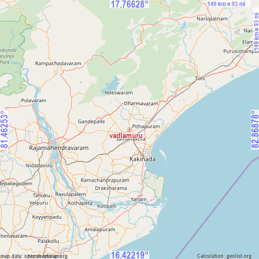
vadlamuru GPS coordinates[2]
17° 5' 43.62" North, 82° 9' 56.34" East
| Map corner | latitude | longitude |
|---|---|---|
| Upper-left | 17.76628°, | 81.46253° |
| Center: | 17.09545°, | 82.16565° |
| Lower-right: | 16.42219°, | 82.86878° |
| Map W x H: | 149.4×149.5 km | = 92.8×92.9mi |
| max Lat: | 34.9274° ⇑74.5% North |
| vadlamuru: | 17.09545° |
| min Lat: | ⇓25.5% South 8.09008° |
| min Long | vadlamuru | max Long |
| 68.82655° | 82.16565° | 96.81° |
| W 77.1%⇐ | ⇒22.9% E |
Elevation
Elevation of vadlamuru is 21 m = 69 ft, and this is 274.6 m = 901 ft below average elevation for this country.
| Max E: |
3681 m = 12077 ft | 88.6% |
| Avg. | 295.6 m = 970 ft | |
| vadlamuru | 21 m = 69 ft | |
Min E: |
1 m = 3 ft | 11.4% |
See also: India elevation on elevation.city.
Geographical zone
vadlamuru is located in North Torrid zone (between Equator and Tropic of Cancer). Distance of this Northern Tropic circle is 705.1 km =438.1 mi to North.| Distance of | km | miles | from vadlamuru |
|---|---|---|---|
| North Pole | 8106.2 | 5037 | to North |
| Arctic Circle | 5500.3 | 3417.7 | to North |
| Tropic Cancer | 705.1 | 438.1 | to North |
| Equator | 1900.8 | 1181.1 | to South |


Nearby cities:
15 places around vadlamuru: (largest is in red/bold)
• Gokavaram
38.1 km =23.7 mi,  298°
298°
• Kovvūr
47.2 km =29.3 mi,  259°
259°
• Kākināda
16.9 km =10.5 mi,  152°
152°
• Mandapeta
36.1 km =22.4 mi,  224°
224°
• Nidadavole
56.5 km =35.1 mi,  248°
248°
• Peddāpuram
3.6 km =2.2 mi,  234°
234°
• Pithāpuram
9.6 km =6 mi,  75°
75°
• Polavaram
58 km =36 mi,  286°
286°
• Ramanayyapeta
18.4 km =11.4 mi,  155°
155°
• Rampachodavaram
56.5 km =35.1 mi,  312°
312°
• Rājahmundry
42.4 km =26.3 mi, 256°
• Rāmachandrapuram
32.3 km =20.1 mi,  206°
206°
• Sāmalkot
4.5 km =2.8 mi,  165°
165°
• Tuni
49.9 km =31 mi,  54°
54°
• Yanam
40.6 km =25.2 mi, 172°
Sources, notices
• [Note1] Compared only with cities in India existing in our database
• [Src1] Map data: © OpenStreetMap contributors (CC-BY-SA)
• [Src2] Other city data from geonames.org with taken over terms of usage.
• [Src3] Geographical zone / Annual Mean Temperature by Robert A. Rohde @ Wikipedia
