Kundla geodata
Kundla (Gujarat) is a populated place; located in India in Asia/Kolkata (GMT+5.5) time zone. With population of 76,809 people, there are 569 cities with bigger population in this country. Compared to other cities in India, 59.7% of cities are located further ↑North; 98.2% of cities are located further →East and 62.7% of cities have higher elevation than Kundla. Note1


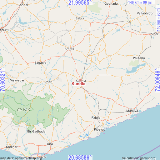
Kundla GPS coordinates[2]
21° 20' 31.992" North, 71° 18' 22.788" East
| Map corner | latitude | longitude |
|---|---|---|
| Upper-left | 21.99565°, | 70.60321° |
| Center: | 21.34222°, | 71.30633° |
| Lower-right: | 20.68586°, | 72.00946° |
| Map W x H: | 145.6×145.6 km | = 90.5×90.5mi |
| max Lat: | 34.9274° ⇑59.7% North |
| Kundla: | 21.34222° |
| min Lat: | ⇓40.3% South 8.09008° |
| min Long | Kundla | max Long |
| 68.82655° | 71.30633° | 96.81° |
| W 1.8%⇐ | ⇒98.2% E |
Elevation
Elevation of Kundla is 134 m = 440 ft, and this is 161.6 m = 530 ft below average elevation for this country.
| Max E: |
3681 m = 12077 ft | 62.7% |
| Avg. | 295.6 m = 970 ft | |
| Kundla | 134 m = 440 ft | |
Min E: |
1 m = 3 ft | 37.3% |
See also: Kundla elevation on elevation.city.
Geographical zone
Kundla is located in North Torrid zone (between Equator and Tropic of Cancer). Distance of this Northern Tropic circle is 232.9 km =144.7 mi to North.| Distance of | km | miles | from Kundla |
|---|---|---|---|
| North Pole | 7634 | 4743.5 | to North |
| Arctic Circle | 5028.1 | 3124.3 | to North |
| Tropic Cancer | 232.9 | 144.7 | to North |
| Equator | 2373 | 1474.5 | to South |


Nearby cities:
15 places around Kundla: (largest is in red/bold)
• Amreli
30.3 km =18.8 mi,  341°
341°
• Bagasra
39.8 km =24.7 mi,  293°
293°
• Bābra
56 km =34.8 mi,  359°
359°
• Chalāla
16.4 km =10.2 mi,  297°
297°
• Dhāri
29 km =18 mi,  266°
266°
• Dungarpur
46.9 km =29.1 mi,  97°
97°
• Dāmnagar
44.6 km =27.7 mi,  29°
29°
• Gariadhar
35.6 km =22.1 mi,  52°
52°
• Katpur
59.6 km =37 mi,  121°
121°
• Lāthi
43.2 km =26.8 mi,  11°
11°
• Pālitāna
57.2 km =35.5 mi,  69°
69°
• Rājula
36.6 km =22.7 mi,  157°
157°
• Savarkundla
0.6 km =0.4 mi,  207°
207°
• Una
64.1 km =39.8 mi, 205°
• Vīsāvadar
57.7 km =35.9 mi, 269°
Sources, notices
• [Note1] Compared only with cities in India existing in our database
• [Src1] Map data: © OpenStreetMap contributors (CC-BY-SA)
• [Src2] Other city data from geonames.org with taken over terms of usage.
• [Src3] Geographical zone / Annual Mean Temperature by Robert A. Rohde @ Wikipedia
