Chalāla geodata
Chalāla (Gujarat) is a populated place; located in India in Asia/Kolkata (GMT+5.5) time zone. With population of 17,081 people, there are 2278 cities with bigger population in this country. Compared to other cities in India, 59.5% of cities are located further ↑North; 98.4% of cities are located further →East and 61.8% of cities have higher elevation than Chalāla. Note1


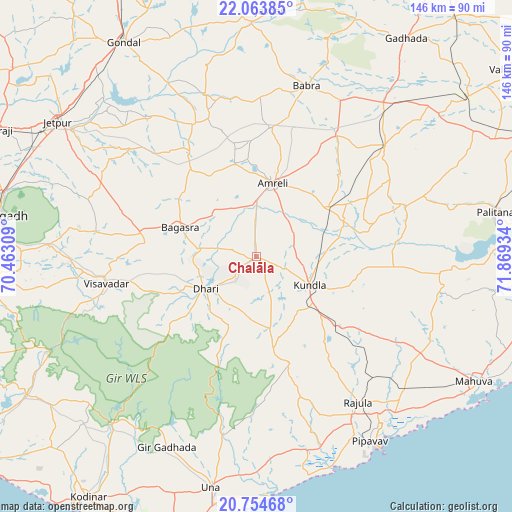
Chalāla GPS coordinates[2]
21° 24' 38.628" North, 71° 9' 58.356" East
| Map corner | latitude | longitude |
|---|---|---|
| Upper-left | 22.06385°, | 70.46309° |
| Center: | 21.41073°, | 71.16621° |
| Lower-right: | 20.75468°, | 71.86934° |
| Map W x H: | 145.6×145.6 km | = 90.5×90.5mi |
| max Lat: | 34.9274° ⇑59.5% North |
| Chalāla: | 21.41073° |
| min Lat: | ⇓40.5% South 8.09008° |
| min Long | Chalāla | max Long |
| 68.82655° | 71.16621° | 96.81° |
| W 1.6%⇐ | ⇒98.4% E |
Elevation
Elevation of Chalāla is 139 m = 456 ft, and this is 156.6 m = 514 ft below average elevation for this country.
| Max E: |
3681 m = 12077 ft | 61.8% |
| Avg. | 295.6 m = 970 ft | |
| Chalāla | 139 m = 456 ft | |
Min E: |
1 m = 3 ft | 38.2% |
See also: India elevation on elevation.city.
Geographical zone
Chalāla is located in North Torrid zone (between Equator and Tropic of Cancer). Distance of this Northern Tropic circle is 225.3 km =140 mi to North.| Distance of | km | miles | from Chalāla |
|---|---|---|---|
| North Pole | 7626.4 | 4738.8 | to North |
| Arctic Circle | 5020.5 | 3119.6 | to North |
| Tropic Cancer | 225.3 | 140 | to North |
| Equator | 2380.7 | 1479.3 | to South |


Nearby cities:
15 places around Chalāla: (largest is in red/bold)
• Amreli
21.5 km =13.4 mi,  12°
12°
• Bagasra
23.4 km =14.5 mi,  291°
291°
• Bilkha
58.6 km =36.4 mi,  273°
273°
• Bābra
50.5 km =31.4 mi,  16°
16°
• Dhāri
17.1 km =10.6 mi,  237°
237°
• Dungarpur
62.5 km =38.8 mi,  102°
102°
• Dāmnagar
48 km =29.8 mi,  49°
49°
• Gariadhar
44.9 km =27.9 mi,  71°
71°
• Jetpur
67.9 km =42.2 mi,  304°
304°
• Kundla
16.4 km =10.2 mi,  117°
117°
• Lāthi
41.6 km =25.8 mi,  33°
33°
• Rājula
50.4 km =31.3 mi,  145°
145°
• Savarkundla
16.4 km =10.2 mi, 119°
• Una
66.7 km =41.4 mi,  191°
191°
• Vīsāvadar
43.9 km =27.3 mi,  259°
259°
Sources, notices
• [Note1] Compared only with cities in India existing in our database
• [Src1] Map data: © OpenStreetMap contributors (CC-BY-SA)
• [Src2] Other city data from geonames.org with taken over terms of usage.
• [Src3] Geographical zone / Annual Mean Temperature by Robert A. Rohde @ Wikipedia
