Muttupet geodata
Muttupet (Tamil Nadu) is a populated place; located in India in Asia/Kolkata (GMT+5.5) time zone. With population of 21,568 people, there are 1930 cities with bigger population in this country. Compared to other cities in India, 95.3% of cities are located further ↑North; 63.8% of cities are located further ←West and 98.3% of cities have higher elevation than Muttupet. Note1


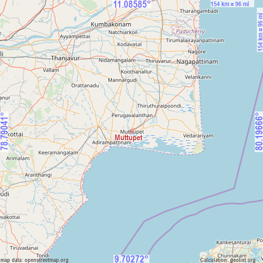
Muttupet GPS coordinates[2]
10° 23' 42.18" North, 79° 29' 36.708" East
| Map corner | latitude | longitude |
|---|---|---|
| Upper-left | 11.08585°, | 78.79041° |
| Center: | 10.39505°, | 79.49353° |
| Lower-right: | 9.70272°, | 80.19666° |
| Map W x H: | 153.8×153.8 km | = 95.6×95.6mi |
| max Lat: | 34.9274° ⇑95.3% North |
| Muttupet: | 10.39505° |
| min Lat: | ⇓4.7% South 8.09008° |
| min Long | Muttupet | max Long |
| 68.82655° | 79.49353° | 96.81° |
| W 63.8%⇐ | ⇒36.2% E |
Elevation
Elevation of Muttupet is 8 m = 26 ft, and this is 287.6 m = 944 ft below average elevation for this country.
| Max E: |
3681 m = 12077 ft | 98.3% |
| Avg. | 295.6 m = 970 ft | |
| Muttupet | 8 m = 26 ft | |
Min E: |
1 m = 3 ft | 1.7% |
See also: India elevation on elevation.city.
Geographical zone
Muttupet is located in North Torrid zone (between Equator and Tropic of Cancer). Distance of Equator is 1155.8 km =718.2 mi to South.| Distance of | km | miles | from Muttupet |
|---|---|---|---|
| North Pole | 8851.2 | 5499.9 | to North |
| Arctic Circle | 6245.4 | 3880.7 | to North |
| Tropic Cancer | 1450.1 | 901.1 | to North |
| Equator | 1155.8 | 718.2 | to South |


Nearby cities:
15 places around Muttupet: (largest is in red/bold)
• Adirampattinam
13.9 km =8.6 mi,  244°
244°
• Ammāpettai
48.3 km =30 mi,  336°
336°
• Karambakkudi
39.2 km =24.4 mi,  280°
280°
• Kilvelur
49.5 km =30.8 mi,  33°
33°
• Koothanallur
36.2 km =22.5 mi,  3°
3°
• Koradāchcheri
41.7 km =25.9 mi,  359°
359°
• Madukkūr
14 km =8.7 mi,  312°
312°
• Mannargudi
30.5 km =19 mi,  351°
351°
• Nannilam
55.3 km =34.4 mi,  13°
13°
• Needamangalam
42.9 km =26.7 mi, 349°
• Pattukkottai
19.3 km =12 mi, 279°
• Peravurani
34 km =21.1 mi,  249°
249°
• Thiruvarur
44.8 km =27.8 mi,  20°
20°
• Vedaraniyam
39.2 km =24.4 mi,  93°
93°
• Velankanni
49.1 km =30.5 mi,  49°
49°
Sources, notices
• [Note1] Compared only with cities in India existing in our database
• [Src1] Map data: © OpenStreetMap contributors (CC-BY-SA)
• [Src2] Other city data from geonames.org with taken over terms of usage.
• [Src3] Geographical zone / Annual Mean Temperature by Robert A. Rohde @ Wikipedia
