Sivakasi geodata
Sivakasi (Tamil Nadu) is a populated place; located in India in Asia/Kolkata (GMT+5.5) time zone. With population of 74,282 people, there are 589 cities with bigger population in this country. Compared to other cities in India, 97.8% of cities are located further ↑North; 53.6% of cities are located further →East and 67.4% of cities have higher elevation than Sivakasi. Note1


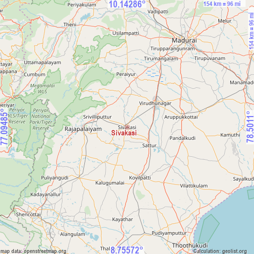
Sivakasi GPS coordinates[2]
9° 26' 59.964" North, 77° 47' 52.692" East
| Map corner | latitude | longitude |
|---|---|---|
| Upper-left | 10.14286°, | 77.09485° |
| Center: | 9.44999°, | 77.79797° |
| Lower-right: | 8.75572°, | 78.5011° |
| Map W x H: | 154.2×154.2 km | = 95.8×95.8mi |
| max Lat: | 34.9274° ⇑97.8% North |
| Sivakasi: | 9.44999° |
| min Lat: | ⇓2.2% South 8.09008° |
| min Long | Sivakasi | max Long |
| 68.82655° | 77.79797° | 96.81° |
| W 46.4%⇐ | ⇒53.6% E |
Elevation
Elevation of Sivakasi is 105 m = 344 ft, and this is 190.6 m = 625 ft below average elevation for this country.
| Max E: |
3681 m = 12077 ft | 67.4% |
| Avg. | 295.6 m = 970 ft | |
| Sivakasi | 105 m = 344 ft | |
Min E: |
1 m = 3 ft | 32.6% |
See also: Sivakasi elevation on elevation.city.
Geographical zone
Sivakasi is located in North Torrid zone (between Equator and Tropic of Cancer). Distance of Equator is 1050.7 km =652.9 mi to South.| Distance of | km | miles | from Sivakasi |
|---|---|---|---|
| North Pole | 8956.3 | 5565.2 | to North |
| Arctic Circle | 6350.4 | 3946 | to North |
| Tropic Cancer | 1555.2 | 966.4 | to North |
| Equator | 1050.7 | 652.9 | to South |


Nearby cities:
15 places around Sivakasi: (largest is in red/bold)
• Aruppukkottai
33.3 km =20.7 mi,  78°
78°
• Cholapuram
27.4 km =17 mi,  246°
246°
• Elāyirampannai
20.2 km =12.6 mi,  171°
171°
• Ettaiyapuram
40.1 km =24.9 mi,  148°
148°
• Kallupatti
30.6 km =19 mi,  14°
14°
• Kalugumalai
34.9 km =21.7 mi,  196°
196°
• Kariapatti
41.5 km =25.8 mi,  52°
52°
• Kovilpatti
31.9 km =19.8 mi, 165°
• Peraiyur
31.8 km =19.8 mi,  358°
358°
• Pudūr
41.3 km =25.7 mi,  115°
115°
• Rajapalaiyam
26.8 km =16.7 mi,  270°
270°
• Sattur
17.4 km =10.8 mi,  126°
126°
• Srivilliputhur
19.3 km =12 mi,  291°
291°
• Tiruttangal
5.4 km =3.4 mi, 46°
• Virudunagar
23.1 km =14.4 mi, 49°
Sources, notices
• [Note1] Compared only with cities in India existing in our database
• [Src1] Map data: © OpenStreetMap contributors (CC-BY-SA)
• [Src2] Other city data from geonames.org with taken over terms of usage.
• [Src3] Geographical zone / Annual Mean Temperature by Robert A. Rohde @ Wikipedia
