Ālangudi geodata
Ālangudi (Tamil Nadu) is a populated place; located in India in Asia/Kolkata (GMT+5.5) time zone. With population of 10,617 people, there are 2881 cities with bigger population in this country. Compared to other cities in India, 95.4% of cities are located further ↑North; 58.9% of cities are located further ←West and 72.7% of cities have higher elevation than Ālangudi. Note1


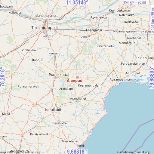
Ālangudi GPS coordinates[2]
10° 21' 38.16" North, 78° 59' 5.712" East
| Map corner | latitude | longitude |
|---|---|---|
| Upper-left | 11.05148°, | 78.2818° |
| Center: | 10.3606°, | 78.98492° |
| Lower-right: | 9.66819°, | 79.68805° |
| Map W x H: | 153.8×153.8 km | = 95.6×95.6mi |
| max Lat: | 34.9274° ⇑95.4% North |
| Ālangudi: | 10.3606° |
| min Lat: | ⇓4.6% South 8.09008° |
| min Long | Ālangudi | max Long |
| 68.82655° | 78.98492° | 96.81° |
| W 58.9%⇐ | ⇒41.1% E |
Elevation
Elevation of Ālangudi is 81 m = 266 ft, and this is 214.6 m = 704 ft below average elevation for this country.
| Max E: |
3681 m = 12077 ft | 72.7% |
| Avg. | 295.6 m = 970 ft | |
| Ālangudi | 81 m = 266 ft | |
Min E: |
1 m = 3 ft | 27.3% |
See also: India elevation on elevation.city.
Geographical zone
Ālangudi is located in North Torrid zone (between Equator and Tropic of Cancer). Distance of Equator is 1152 km =715.8 mi to South.| Distance of | km | miles | from Ālangudi |
|---|---|---|---|
| North Pole | 8855.1 | 5502.3 | to North |
| Arctic Circle | 6249.2 | 3883.1 | to North |
| Tropic Cancer | 1453.9 | 903.4 | to North |
| Equator | 1152 | 715.8 | to South |


Nearby cities:
15 places around Ālangudi: (largest is in red/bold)
• Annavāsal
33.1 km =20.6 mi,  289°
289°
• Arantāngi
20.9 km =13 mi,  178°
178°
• Arimalam
16.1 km =10 mi,  223°
223°
• Iluppūr
43 km =26.7 mi, 293°
• Kanadukattan
30.7 km =19.1 mi,  227°
227°
• Karambakkudi
20.3 km =12.6 mi,  57°
57°
• Kottaiyūr
34.8 km =21.6 mi, 216°
• Kāraikkudi
40.4 km =25.1 mi, 215°
• Kīranūr
31.8 km =19.8 mi,  317°
317°
• Pallattūr
31.1 km =19.3 mi, 219°
• Pattukkottai
37.3 km =23.2 mi,  79°
79°
• Peravurani
25 km =15.5 mi,  108°
108°
• Pudukkottai
18 km =11.2 mi,  277°
277°
• Puliyūr
34.2 km =21.3 mi,  332°
332°
• Vallam
40.8 km =25.4 mi,  11°
11°
Sources, notices
• [Note1] Compared only with cities in India existing in our database
• [Src1] Map data: © OpenStreetMap contributors (CC-BY-SA)
• [Src2] Other city data from geonames.org with taken over terms of usage.
• [Src3] Geographical zone / Annual Mean Temperature by Robert A. Rohde @ Wikipedia
