Tsrār Sharīf geodata
Tsrār Sharīf (Jammu and Kashmir) is a populated place; located in India in Asia/Kolkata (GMT+5.5) time zone. With population of 8,036 people, there are 3123 cities with bigger population in this country. Compared to other cities in India, 99.4% of cities are located further ↓South; 84.7% of cities are located further →East and 99.3% of cities have lower elevation than Tsrār Sharīf. Note1


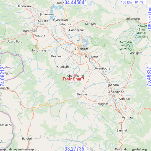
Tsrār Sharīf GPS coordinates[2]
33° 51' 47.484" North, 74° 45' 54.864" East
| Map corner | latitude | longitude |
|---|---|---|
| Upper-left | 34.44504°, | 74.06212° |
| Center: | 33.86319°, | 74.76524° |
| Lower-right: | 33.27735°, | 75.46837° |
| Map W x H: | 129.8×129.8 km | = 80.7×80.7mi |
| max Lat: | 34.9274° ⇑0.6% North |
| Tsrār Sharīf: | 33.86319° |
| min Lat: | ⇓99.4% South 8.09008° |
| min Long | Tsrār Sharīf | max Long |
| 68.82655° | 74.76524° | 96.81° |
| W 15.3%⇐ | ⇒84.7% E |
Elevation
Elevation of Tsrār Sharīf is 1953 m = 6407 ft, and this is 1657.4 m = 5438 ft above average elevation for this country.
| Max E: |
3681 m = 12077 ft | 0.7% |
| Tsrār Sharīf | 1953 m 6407 ft | |
| Avg. | 295.6 m = 970 ft | |
Min E: |
1 m = 3 ft | 99.3% |
See also: India elevation on elevation.city.
Geographical zone
Tsrār Sharīf is located in North temperate zone (between Tropic of Cancer and the Arctic Circle). Distance of this Northern Tropic circle is 1159.3 km =720.4 mi to South.| Distance of | km | miles | from Tsrār Sharīf |
|---|---|---|---|
| North Pole | 6241.8 | 3878.5 | to North |
| Arctic Circle | 3635.9 | 2259.2 | to North |
| Tropic Cancer | 1159.3 | 720.4 | to South |
| Equator | 3765.2 | 2339.6 | to South |


Nearby cities:
15 places around Tsrār Sharīf: (largest is in red/bold)
• Anantnag
38.8 km =24.1 mi,  112°
112°
• Awantipur
23.9 km =14.9 mi,  74°
74°
• Bijbehara
32.5 km =20.2 mi,  103°
103°
• Gulmarg
41.2 km =25.6 mi,  300°
300°
• Gāndarbal
40.4 km =25.1 mi,  1°
1°
• Kulgam
33.8 km =21 mi,  135°
135°
• Māgām
30.2 km =18.8 mi,  327°
327°
• Pattan
38.3 km =23.8 mi, 329°
• Pulwama
12.5 km =7.8 mi,  84°
84°
• Qāzigund
42.9 km =26.7 mi,  125°
125°
• Shupīyan
17.4 km =10.8 mi,  158°
158°
• Soyībug
24.4 km =15.2 mi,  346°
346°
• Srinagar
25 km =15.5 mi,  8°
8°
• Sumbal
42.3 km =26.3 mi, 345°
• Trāl
33.1 km =20.6 mi, 77°
Sources, notices
• [Note1] Compared only with cities in India existing in our database
• [Src1] Map data: © OpenStreetMap contributors (CC-BY-SA)
• [Src2] Other city data from geonames.org with taken over terms of usage.
• [Src3] Geographical zone / Annual Mean Temperature by Robert A. Rohde @ Wikipedia
