Trāl geodata
Trāl (Jammu and Kashmir) is a populated place; located in India in Asia/Kolkata (GMT+5.5) time zone. With population of 13,255 people, there are 2631 cities with bigger population in this country. Compared to other cities in India, 99.5% of cities are located further ↓South; 81.8% of cities are located further →East and 98.9% of cities have lower elevation than Trāl. Note1


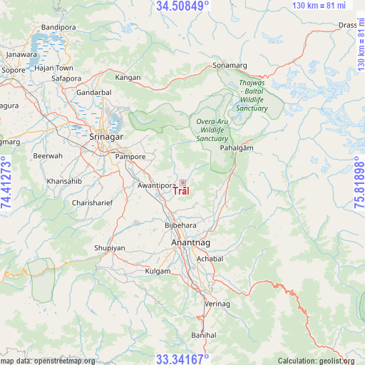
Trāl GPS coordinates[2]
33° 55' 37.488" North, 75° 6' 57.06" East
| Map corner | latitude | longitude |
|---|---|---|
| Upper-left | 34.50849°, | 74.41273° |
| Center: | 33.92708°, | 75.11585° |
| Lower-right: | 33.34167°, | 75.81898° |
| Map W x H: | 129.7×129.7 km | = 80.6×80.6mi |
| max Lat: | 34.9274° ⇑0.5% North |
| Trāl: | 33.92708° |
| min Lat: | ⇓99.5% South 8.09008° |
| min Long | Trāl | max Long |
| 68.82655° | 75.11585° | 96.81° |
| W 18.2%⇐ | ⇒81.8% E |
Elevation
Elevation of Trāl is 1713 m = 5620 ft, and this is 1417.4 m = 4650 ft above average elevation for this country.
| Max E: |
3681 m = 12077 ft | 1.1% |
| Trāl | 1713 m 5620 ft | |
| Avg. | 295.6 m = 970 ft | |
Min E: |
1 m = 3 ft | 98.9% |
See also: India elevation on elevation.city.
Geographical zone
Trāl is located in North temperate zone (between Tropic of Cancer and the Arctic Circle). Distance of this Northern Tropic circle is 1166.4 km =724.8 mi to South.| Distance of | km | miles | from Trāl |
|---|---|---|---|
| North Pole | 6234.7 | 3874.1 | to North |
| Arctic Circle | 3628.8 | 2254.8 | to North |
| Tropic Cancer | 1166.4 | 724.8 | to South |
| Equator | 3772.3 | 2344 | to South |


Nearby cities:
15 places around Trāl: (largest is in red/bold)
• Anantnag
22.1 km =13.7 mi,  170°
170°
• Awantipur
9.3 km =5.8 mi,  265°
265°
• Banihāl
55.1 km =34.2 mi, 172°
• Bijbehara
14.8 km =9.2 mi,  183°
183°
• Gāndarbal
45.7 km =28.4 mi,  316°
316°
• Kulgam
32.7 km =20.3 mi,  195°
195°
• Māgām
51.8 km =32.2 mi,  290°
290°
• Pahlgām
21.2 km =13.2 mi,  62°
62°
• Pulwama
20.8 km =12.9 mi,  253°
253°
• Qāzigund
32.2 km =20 mi, 175°
• Shupīyan
35 km =21.7 mi,  228°
228°
• Soyībug
41.3 km =25.7 mi, 293°
• Srinagar
33.6 km =20.9 mi,  301°
301°
• Sumbal
54.8 km =34.1 mi,  308°
308°
• Tsrār Sharīf
33.1 km =20.6 mi,  257°
257°
Sources, notices
• [Note1] Compared only with cities in India existing in our database
• [Src1] Map data: © OpenStreetMap contributors (CC-BY-SA)
• [Src2] Other city data from geonames.org with taken over terms of usage.
• [Src3] Geographical zone / Annual Mean Temperature by Robert A. Rohde @ Wikipedia
