Shupīyan geodata
Shupīyan (Jammu and Kashmir) is a populated place; located in India in Asia/Kolkata (GMT+5.5) time zone. With population of 13,565 people, there are 2609 cities with bigger population in this country. Compared to other cities in India, 99.3% of cities are located further ↓South; 84.1% of cities are located further →East and 99.3% of cities have lower elevation than Shupīyan. Note1


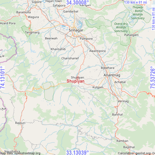
Shupīyan GPS coordinates[2]
33° 43' 2.028" North, 74° 50' 2.868" East
| Map corner | latitude | longitude |
|---|---|---|
| Upper-left | 34.30008°, | 74.13101° |
| Center: | 33.71723°, | 74.83413° |
| Lower-right: | 33.13039°, | 75.53726° |
| Map W x H: | 130.1×130.1 km | = 80.8×80.8mi |
| max Lat: | 34.9274° ⇑0.7% North |
| Shupīyan: | 33.71723° |
| min Lat: | ⇓99.3% South 8.09008° |
| min Long | Shupīyan | max Long |
| 68.82655° | 74.83413° | 96.81° |
| W 15.9%⇐ | ⇒84.1% E |
Elevation
Elevation of Shupīyan is 2055 m = 6742 ft, and this is 1759.4 m = 5772 ft above average elevation for this country.
| Max E: |
3681 m = 12077 ft | 0.7% |
| Shupīyan | 2055 m 6742 ft | |
| Avg. | 295.6 m = 970 ft | |
Min E: |
1 m = 3 ft | 99.3% |
See also: India elevation on elevation.city.
Geographical zone
Shupīyan is located in North temperate zone (between Tropic of Cancer and the Arctic Circle). Distance of this Northern Tropic circle is 1143.1 km =710.3 mi to South.| Distance of | km | miles | from Shupīyan |
|---|---|---|---|
| North Pole | 6258.1 | 3888.6 | to North |
| Arctic Circle | 3652.2 | 2269.4 | to North |
| Tropic Cancer | 1143.1 | 710.3 | to South |
| Equator | 3749 | 2329.5 | to South |


Nearby cities:
15 places around Shupīyan: (largest is in red/bold)
• Anantnag
29.6 km =18.4 mi,  87°
87°
• Awantipur
28.1 km =17.5 mi,  36°
36°
• Banihāl
45.9 km =28.5 mi,  132°
132°
• Bijbehara
26.6 km =16.5 mi,  71°
71°
• Kulgam
18.9 km =11.7 mi,  115°
115°
• Māgām
47.4 km =29.5 mi,  331°
331°
• Pahlgām
55.7 km =34.6 mi,  53°
53°
• Pattan
55.6 km =34.5 mi, 332°
• Pulwama
18.5 km =11.5 mi,  19°
19°
• Qāzigund
29.9 km =18.6 mi,  107°
107°
• Soyībug
41.7 km =25.9 mi,  343°
343°
• Srinagar
41 km =25.5 mi,  356°
356°
• Thanna Mandi
46.3 km =28.8 mi,  245°
245°
• Trāl
35 km =21.7 mi, 48°
• Tsrār Sharīf
17.4 km =10.8 mi, 338°
Sources, notices
• [Note1] Compared only with cities in India existing in our database
• [Src1] Map data: © OpenStreetMap contributors (CC-BY-SA)
• [Src2] Other city data from geonames.org with taken over terms of usage.
• [Src3] Geographical zone / Annual Mean Temperature by Robert A. Rohde @ Wikipedia
