Srinagar geodata
Srinagar (Jammu and Kashmir) is a seat of a first-order administrative division; located in India in Asia/Kolkata (GMT+5.5) time zone. With population of 975,857 people, there are 43 cities with bigger population in this country. Compared to other cities in India, 99.7% of cities are located further ↓South; 84.2% of cities are located further →East and 98.2% of cities have lower elevation than Srinagar. Note1


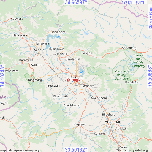
Srinagar GPS coordinates[2]
34° 5' 8.34" North, 74° 48' 19.98" East
| Map corner | latitude | longitude |
|---|---|---|
| Upper-left | 34.66597°, | 74.10243° |
| Center: | 34.08565°, | 74.80555° |
| Lower-right: | 33.50132°, | 75.50868° |
| Map W x H: | 129.5×129.5 km | = 80.5×80.5mi |
| max Lat: | 34.9274° ⇑0.3% North |
| Srinagar: | 34.08565° |
| min Lat: | ⇓99.7% South 8.09008° |
| min Long | Srinagar | max Long |
| 68.82655° | 74.80555° | 96.81° |
| W 15.8%⇐ | ⇒84.2% E |
Elevation
Elevation of Srinagar is 1589 m = 5213 ft, and this is 1293.4 m = 4243 ft above average elevation for this country.
| Max E: |
3681 m = 12077 ft | 1.8% |
| Srinagar | 1589 m 5213 ft | |
| Avg. | 295.6 m = 970 ft | |
Min E: |
1 m = 3 ft | 98.2% |
See also: Srinagar elevation on elevation.city.
Geographical zone
Srinagar is located in North temperate zone (between Tropic of Cancer and the Arctic Circle). Distance of this Northern Tropic circle is 1184.1 km =735.8 mi to South.| Distance of | km | miles | from Srinagar |
|---|---|---|---|
| North Pole | 6217.1 | 3863.1 | to North |
| Arctic Circle | 3611.2 | 2243.9 | to North |
| Tropic Cancer | 1184.1 | 735.8 | to South |
| Equator | 3790 | 2355 | to South |


Nearby cities:
15 places around Srinagar: (largest is in red/bold)
• Awantipur
26.7 km =16.6 mi,  133°
133°
• Bandipura
39.8 km =24.7 mi,  337°
337°
• Bijbehara
42.7 km =26.5 mi,  139°
139°
• Gulmarg
39.2 km =24.4 mi,  264°
264°
• Gāndarbal
15.9 km =9.9 mi,  349°
349°
• Hājan
29.4 km =18.3 mi,  323°
323°
• Māgām
19.8 km =12.3 mi,  272°
272°
• Pattan
24.4 km =15.2 mi,  290°
290°
• Pulwama
25.1 km =15.6 mi,  159°
159°
• Shupīyan
41 km =25.5 mi,  176°
176°
• Sopur
37.9 km =23.5 mi,  306°
306°
• Soyībug
9.2 km =5.7 mi, 263°
• Sumbal
21.7 km =13.5 mi, 317°
• Trāl
33.6 km =20.9 mi,  121°
121°
• Tsrār Sharīf
25 km =15.5 mi,  188°
188°
Sources, notices
• [Note1] Compared only with cities in India existing in our database
• [Src1] Map data: © OpenStreetMap contributors (CC-BY-SA)
• [Src2] Other city data from geonames.org with taken over terms of usage.
• [Src3] Geographical zone / Annual Mean Temperature by Robert A. Rohde @ Wikipedia
