Qāzigund geodata
Qāzigund (Jammu and Kashmir) is a populated place; located in India in Asia/Kolkata (GMT+5.5) time zone. With population of 5,576 people, there are 3317 cities with bigger population in this country. Compared to other cities in India, 99.3% of cities are located further ↓South; 81.4% of cities are located further →East and 98.7% of cities have lower elevation than Qāzigund. Note1


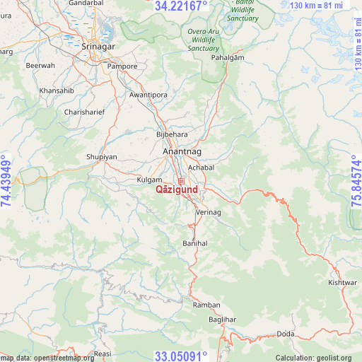
Qāzigund GPS coordinates[2]
33° 38' 17.808" North, 75° 8' 33.396" East
| Map corner | latitude | longitude |
|---|---|---|
| Upper-left | 34.22167°, | 74.43949° |
| Center: | 33.63828°, | 75.14261° |
| Lower-right: | 33.05091°, | 75.84574° |
| Map W x H: | 130.2×130.2 km | = 80.9×80.9mi |
| max Lat: | 34.9274° ⇑0.7% North |
| Qāzigund: | 33.63828° |
| min Lat: | ⇓99.3% South 8.09008° |
| min Long | Qāzigund | max Long |
| 68.82655° | 75.14261° | 96.81° |
| W 18.6%⇐ | ⇒81.4% E |
Elevation
Elevation of Qāzigund is 1666 m = 5466 ft, and this is 1370.4 m = 4496 ft above average elevation for this country.
| Max E: |
3681 m = 12077 ft | 1.3% |
| Qāzigund | 1666 m 5466 ft | |
| Avg. | 295.6 m = 970 ft | |
Min E: |
1 m = 3 ft | 98.7% |
See also: India elevation on elevation.city.
Geographical zone
Qāzigund is located in North temperate zone (between Tropic of Cancer and the Arctic Circle). Distance of this Northern Tropic circle is 1134.3 km =704.8 mi to South.| Distance of | km | miles | from Qāzigund |
|---|---|---|---|
| North Pole | 6266.8 | 3894 | to North |
| Arctic Circle | 3660.9 | 2274.8 | to North |
| Tropic Cancer | 1134.3 | 704.8 | to South |
| Equator | 3740.2 | 2324.1 | to South |


Nearby cities:
15 places around Qāzigund: (largest is in red/bold)
• Anantnag
10.3 km =6.4 mi,  5°
5°
• Awantipur
33.4 km =20.8 mi,  339°
339°
• Banihāl
23 km =14.3 mi,  167°
167°
• Batoti
59.8 km =37.2 mi, 165°
• Bijbehara
17.6 km =10.9 mi,  349°
349°
• Kulgam
11.4 km =7.1 mi,  273°
273°
• Kūd
64.3 km =40 mi, 167°
• Pahlgām
45 km =28 mi,  21°
21°
• Pulwama
34.5 km =21.4 mi,  319°
319°
• Rāmban
44.8 km =27.8 mi, 168°
• Shupīyan
29.9 km =18.6 mi,  287°
287°
• Soyībug
63.3 km =39.3 mi, 320°
• Srinagar
58.7 km =36.5 mi,  327°
327°
• Trāl
32.2 km =20 mi,  355°
355°
• Tsrār Sharīf
42.9 km =26.7 mi,  305°
305°
Sources, notices
• [Note1] Compared only with cities in India existing in our database
• [Src1] Map data: © OpenStreetMap contributors (CC-BY-SA)
• [Src2] Other city data from geonames.org with taken over terms of usage.
• [Src3] Geographical zone / Annual Mean Temperature by Robert A. Rohde @ Wikipedia
