Kulgam geodata
Kulgam (Jammu and Kashmir) is a populated place; located in India in Asia/Kolkata (GMT+5.5) time zone. With population of 16,246 people, there are 2352 cities with bigger population in this country. Compared to other cities in India, 99.3% of cities are located further ↓South; 82.6% of cities are located further →East and 98.9% of cities have lower elevation than Kulgam. Note1


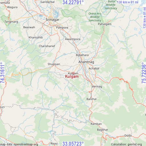
Kulgam GPS coordinates[2]
33° 38' 40.416" North, 75° 1' 9.228" East
| Map corner | latitude | longitude |
|---|---|---|
| Upper-left | 34.22791°, | 74.31611° |
| Center: | 33.64456°, | 75.01923° |
| Lower-right: | 33.05723°, | 75.72236° |
| Map W x H: | 130.2×130.2 km | = 80.9×80.9mi |
| max Lat: | 34.9274° ⇑0.7% North |
| Kulgam: | 33.64456° |
| min Lat: | ⇓99.3% South 8.09008° |
| min Long | Kulgam | max Long |
| 68.82655° | 75.01923° | 96.81° |
| W 17.4%⇐ | ⇒82.6% E |
Elevation
Elevation of Kulgam is 1742 m = 5715 ft, and this is 1446.4 m = 4745 ft above average elevation for this country.
| Max E: |
3681 m = 12077 ft | 1.1% |
| Kulgam | 1742 m 5715 ft | |
| Avg. | 295.6 m = 970 ft | |
Min E: |
1 m = 3 ft | 98.9% |
See also: India elevation on elevation.city.
Geographical zone
Kulgam is located in North temperate zone (between Tropic of Cancer and the Arctic Circle). Distance of this Northern Tropic circle is 1135 km =705.3 mi to South.| Distance of | km | miles | from Kulgam |
|---|---|---|---|
| North Pole | 6266.1 | 3893.6 | to North |
| Arctic Circle | 3660.2 | 2274.3 | to North |
| Tropic Cancer | 1135 | 705.3 | to South |
| Equator | 3740.9 | 2324.5 | to South |


Nearby cities:
15 places around Kulgam: (largest is in red/bold)
• Anantnag
15.7 km =9.8 mi,  52°
52°
• Awantipur
30.6 km =19 mi,  359°
359°
• Banihāl
28.4 km =17.6 mi,  144°
144°
• Bijbehara
18.5 km =11.5 mi,  26°
26°
• Māgām
63.6 km =39.5 mi,  321°
321°
• Pahlgām
49.7 km =30.9 mi, 33°
• Pulwama
27.8 km =17.3 mi,  336°
336°
• Qāzigund
11.4 km =7.1 mi,  93°
93°
• Rāmban
49 km =30.4 mi,  155°
155°
• Shupīyan
18.9 km =11.7 mi,  295°
295°
• Soyībug
56.1 km =34.9 mi,  328°
328°
• Srinagar
52.9 km =32.9 mi, 338°
• Thanna Mandi
60.2 km =37.4 mi,  259°
259°
• Trāl
32.7 km =20.3 mi,  15°
15°
• Tsrār Sharīf
33.8 km =21 mi, 315°
Sources, notices
• [Note1] Compared only with cities in India existing in our database
• [Src1] Map data: © OpenStreetMap contributors (CC-BY-SA)
• [Src2] Other city data from geonames.org with taken over terms of usage.
• [Src3] Geographical zone / Annual Mean Temperature by Robert A. Rohde @ Wikipedia
