Tiruchchendur geodata
Tiruchchendur (Tamil Nadu) is a populated place; located in India in Asia/Kolkata (GMT+5.5) time zone. With population of 29,872 people, there are 1450 cities with bigger population in this country. Compared to other cities in India, 99.5% of cities are located further ↑North; 50.1% of cities are located further ←West and 97.4% of cities have higher elevation than Tiruchchendur. Note1


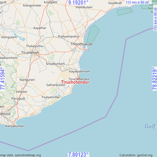
Tiruchchendur GPS coordinates[2]
8° 29' 50.1" North, 78° 7' 8.616" East
| Map corner | latitude | longitude |
|---|---|---|
| Upper-left | 9.19201°, | 77.41594° |
| Center: | 8.49725°, | 78.11906° |
| Lower-right: | 7.80123°, | 78.82219° |
| Map W x H: | 154.6×154.6 km | = 96.1×96.1mi |
| max Lat: | 34.9274° ⇑99.5% North |
| Tiruchchendur: | 8.49725° |
| min Lat: | ⇓0.5% South 8.09008° |
| min Long | Tiruchchendur | max Long |
| 68.82655° | 78.11906° | 96.81° |
| W 50.1%⇐ | ⇒49.9% E |
Elevation
Elevation of Tiruchchendur is 9 m = 30 ft, and this is 286.6 m = 940 ft below average elevation for this country.
| Max E: |
3681 m = 12077 ft | 97.4% |
| Avg. | 295.6 m = 970 ft | |
| Tiruchchendur | 9 m = 30 ft | |
Min E: |
1 m = 3 ft | 2.6% |
See also: India elevation on elevation.city.
Geographical zone
Tiruchchendur is located in North Torrid zone (between Equator and Tropic of Cancer). Distance of Equator is 944.8 km =587.1 mi to South.| Distance of | km | miles | from Tiruchchendur |
|---|---|---|---|
| North Pole | 9062.3 | 5631.1 | to North |
| Arctic Circle | 6456.4 | 4011.8 | to North |
| Tropic Cancer | 1661.1 | 1032.2 | to North |
| Equator | 944.8 | 587.1 | to South |


Nearby cities:
15 places around Tiruchchendur: (largest is in red/bold)
• Alwa Tirunagari
23.1 km =14.4 mi,  301°
301°
• Arumuganeri
8.5 km =5.3 mi,  338°
338°
• Eral
17.8 km =11.1 mi,  323°
323°
• Gangaikondān
54.7 km =34 mi, 317°
• Kayalpattinam
8.2 km =5.1 mi,  0°
0°
• Korampallam
31 km =19.3 mi,  354°
354°
• Kulattūr
56.8 km =35.3 mi,  8°
8°
• Nanguneri
50.7 km =31.5 mi,  269°
269°
• Sathankulam
23.4 km =14.5 mi,  254°
254°
• Srivaikuntam
27 km =16.8 mi, 302°
• Thoothukudi
30.1 km =18.7 mi, 3°
• Tirunelveli
54.3 km =33.7 mi, 298°
• Tisaiyanvilai
32.9 km =20.4 mi,  237°
237°
• Udangudi
12.4 km =7.7 mi,  232°
232°
• Vadakku Valliyūr
57.2 km =35.5 mi,  257°
257°
Sources, notices
• [Note1] Compared only with cities in India existing in our database
• [Src1] Map data: © OpenStreetMap contributors (CC-BY-SA)
• [Src2] Other city data from geonames.org with taken over terms of usage.
• [Src3] Geographical zone / Annual Mean Temperature by Robert A. Rohde @ Wikipedia
