Kayalpattinam geodata
Kayalpattinam (Tamil Nadu) is a populated place; located in India in Asia/Kolkata (GMT+5.5) time zone. With population of 36,175 people, there are 1205 cities with bigger population in this country. Compared to other cities in India, 99.5% of cities are located further ↑North; 50.1% of cities are located further ←West and 99.7% of cities have higher elevation than Kayalpattinam. Note1


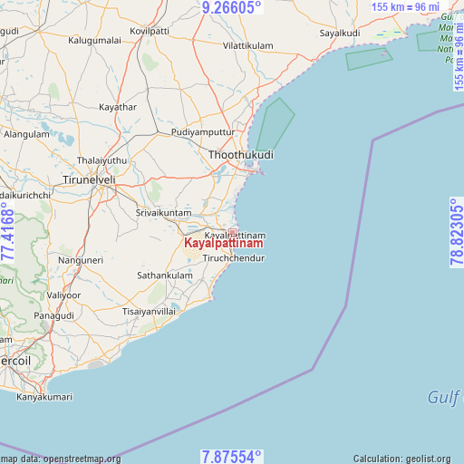
Kayalpattinam GPS coordinates[2]
8° 34' 17.148" North, 78° 7' 11.712" East
| Map corner | latitude | longitude |
|---|---|---|
| Upper-left | 9.26605°, | 77.4168° |
| Center: | 8.57143°, | 78.11992° |
| Lower-right: | 7.87554°, | 78.82305° |
| Map W x H: | 154.6×154.6 km | = 96.1×96.1mi |
| max Lat: | 34.9274° ⇑99.5% North |
| Kayalpattinam: | 8.57143° |
| min Lat: | ⇓0.5% South 8.09008° |
| min Long | Kayalpattinam | max Long |
| 68.82655° | 78.11992° | 96.81° |
| W 50.1%⇐ | ⇒49.9% E |
Elevation
Elevation of Kayalpattinam is 4 m = 13 ft, and this is 291.6 m = 957 ft below average elevation for this country.
| Max E: |
3681 m = 12077 ft | 99.7% |
| Avg. | 295.6 m = 970 ft | |
| Kayalpattinam | 4 m = 13 ft | |
Min E: |
1 m = 3 ft | 0.3% |
See also: India elevation on elevation.city.
Geographical zone
Kayalpattinam is located in North Torrid zone (between Equator and Tropic of Cancer). Distance of Equator is 953.1 km =592.2 mi to South.| Distance of | km | miles | from Kayalpattinam |
|---|---|---|---|
| North Pole | 9054 | 5625.9 | to North |
| Arctic Circle | 6448.1 | 4006.7 | to North |
| Tropic Cancer | 1652.9 | 1027.1 | to North |
| Equator | 953.1 | 592.2 | to South |


Nearby cities:
15 places around Kayalpattinam: (largest is in red/bold)
• Alwa Tirunagari
20.2 km =12.6 mi,  281°
281°
• Arumuganeri
3.2 km =2 mi,  264°
264°
• Eral
12.3 km =7.6 mi,  299°
299°
• Gangaikondān
49.1 km =30.5 mi,  310°
310°
• Kadambūr
55.2 km =34.3 mi,  329°
329°
• Korampallam
22.9 km =14.2 mi,  352°
352°
• Kulattūr
48.7 km =30.3 mi,  9°
9°
• Nanguneri
51.5 km =32 mi, 260°
• Sathankulam
26.9 km =16.7 mi,  237°
237°
• Srivaikuntam
23.7 km =14.7 mi,  285°
285°
• Thoothukudi
21.8 km =13.5 mi,  4°
4°
• Tiruchchendur
8.2 km =5.1 mi,  180°
180°
• Tirunelveli
51 km =31.7 mi, 289°
• Tisaiyanvilai
38.1 km =23.7 mi,  226°
226°
• Udangudi
18.7 km =11.6 mi,  212°
212°
Sources, notices
• [Note1] Compared only with cities in India existing in our database
• [Src1] Map data: © OpenStreetMap contributors (CC-BY-SA)
• [Src2] Other city data from geonames.org with taken over terms of usage.
• [Src3] Geographical zone / Annual Mean Temperature by Robert A. Rohde @ Wikipedia
