Kulattūr geodata
Kulattūr (Tamil Nadu) is a populated place; located in India in Asia/Kolkata (GMT+5.5) time zone. With population of 10,632 people, there are 2878 cities with bigger population in this country. Compared to other cities in India, 98.8% of cities are located further ↑North; 51% of cities are located further ←West and 90.4% of cities have higher elevation than Kulattūr. Note1


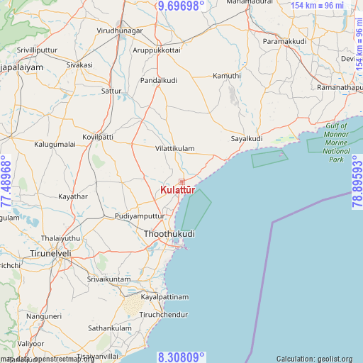
Kulattūr GPS coordinates[2]
9° 0' 11.52" North, 78° 11' 34.08" East
| Map corner | latitude | longitude |
|---|---|---|
| Upper-left | 9.69698°, | 77.48968° |
| Center: | 9.0032°, | 78.1928° |
| Lower-right: | 8.30809°, | 78.89593° |
| Map W x H: | 154.4×154.4 km | = 95.9×95.9mi |
| max Lat: | 34.9274° ⇑98.8% North |
| Kulattūr: | 9.0032° |
| min Lat: | ⇓1.2% South 8.09008° |
| min Long | Kulattūr | max Long |
| 68.82655° | 78.1928° | 96.81° |
| W 51%⇐ | ⇒49% E |
Elevation
Elevation of Kulattūr is 17 m = 56 ft, and this is 278.6 m = 914 ft below average elevation for this country.
| Max E: |
3681 m = 12077 ft | 90.4% |
| Avg. | 295.6 m = 970 ft | |
| Kulattūr | 17 m = 56 ft | |
Min E: |
1 m = 3 ft | 9.6% |
See also: India elevation on elevation.city.
Geographical zone
Kulattūr is located in North Torrid zone (between Equator and Tropic of Cancer). Distance of Equator is 1001.1 km =622.1 mi to South.| Distance of | km | miles | from Kulattūr |
|---|---|---|---|
| North Pole | 9006 | 5596.1 | to North |
| Arctic Circle | 6400.1 | 3976.8 | to North |
| Tropic Cancer | 1604.9 | 997.2 | to North |
| Equator | 1001.1 | 622.1 | to South |


Nearby cities:
15 places around Kulattūr: (largest is in red/bold)
• Arumuganeri
49.6 km =30.8 mi,  193°
193°
• Eral
45.9 km =28.5 mi,  203°
203°
• Ettaiyapuram
27.2 km =16.9 mi,  305°
305°
• Gangaikondān
48.1 km =29.9 mi,  250°
250°
• Kadambūr
36.3 km =22.6 mi,  268°
268°
• Kamuthi
49.1 km =30.5 mi,  23°
23°
• Kayalpattinam
48.7 km =30.3 mi, 189°
• Kayattār
46.4 km =28.8 mi,  262°
262°
• Korampallam
27.7 km =17.2 mi, 203°
• Kovilpatti
40.1 km =24.9 mi,  297°
297°
• Pudūr
32.6 km =20.3 mi,  349°
349°
• Sattur
49 km =30.4 mi,  323°
323°
• Sāyalkudi
33.5 km =20.8 mi,  56°
56°
• Thoothukudi
27 km =16.8 mi, 193°
• Vilattikulam
14.6 km =9.1 mi, 348°
Sources, notices
• [Note1] Compared only with cities in India existing in our database
• [Src1] Map data: © OpenStreetMap contributors (CC-BY-SA)
• [Src2] Other city data from geonames.org with taken over terms of usage.
• [Src3] Geographical zone / Annual Mean Temperature by Robert A. Rohde @ Wikipedia
