Tādepallegūdem geodata
Tādepallegūdem (Andhra Pradesh) is a populated place; located in India in Asia/Kolkata (GMT+5.5) time zone. With population of 108,167 people, there are 410 cities with bigger population in this country. Compared to other cities in India, 75.3% of cities are located further ↑North; 74.8% of cities are located further ←West and 88.6% of cities have higher elevation than Tādepallegūdem. Note1


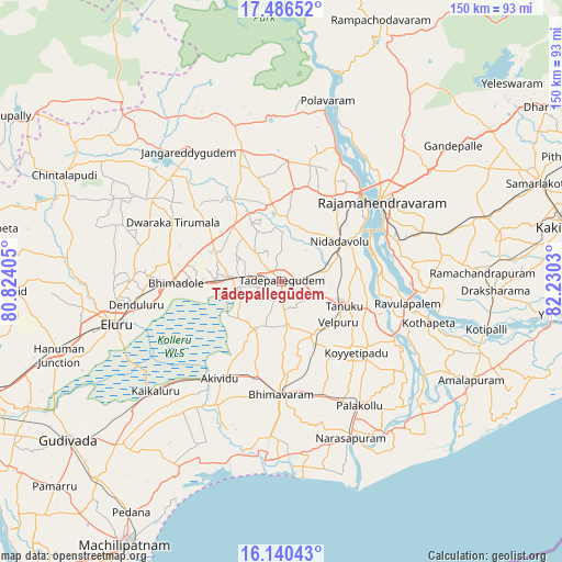
Tādepallegūdem GPS coordinates[2]
16° 48' 52.812" North, 81° 31' 37.812" East
| Map corner | latitude | longitude |
|---|---|---|
| Upper-left | 17.48652°, | 80.82405° |
| Center: | 16.81467°, | 81.52717° |
| Lower-right: | 16.14043°, | 82.2303° |
| Map W x H: | 149.7×149.7 km | = 93×93mi |
| max Lat: | 34.9274° ⇑75.3% North |
| Tādepallegūdem: | 16.81467° |
| min Lat: | ⇓24.7% South 8.09008° |
| min Long | Tādepallegūde | max Long |
| 68.82655° | 81.52717° | 96.81° |
| W 74.8%⇐ | ⇒25.2% E |
Elevation
Elevation of Tādepallegūdem is 21 m = 69 ft, and this is 274.6 m = 901 ft below average elevation for this country.
| Max E: |
3681 m = 12077 ft | 88.6% |
| Avg. | 295.6 m = 970 ft | |
| Tādepallegūdem | 21 m = 69 ft | |
Min E: |
1 m = 3 ft | 11.4% |
See also: Tādepallegūdem elevation on elevation.city.
Geographical zone
Tādepallegūdem is located in North Torrid zone (between Equator and Tropic of Cancer). Distance of this Northern Tropic circle is 736.3 km =457.5 mi to North.| Distance of | km | miles | from Tādepallegūdem |
|---|---|---|---|
| North Pole | 8137.4 | 5056.3 | to North |
| Arctic Circle | 5531.6 | 3437.2 | to North |
| Tropic Cancer | 736.3 | 457.5 | to North |
| Equator | 1869.6 | 1161.7 | to South |


Nearby cities:
15 places around Tādepallegūdem: (largest is in red/bold)
• Akivīdu
30.2 km =18.8 mi,  211°
211°
• Attili
14.9 km =9.3 mi,  148°
148°
• Bhīmavaram
30.5 km =19 mi,  180°
180°
• Kaikalūr
44.4 km =27.6 mi,  228°
228°
• Korukollu
45.8 km =28.5 mi,  220°
220°
• Kovvūr
31.1 km =19.3 mi,  43°
43°
• Mandapeta
43.1 km =26.8 mi,  82°
82°
• Narasapur
46.1 km =28.6 mi,  156°
156°
• Nidadavole
18.5 km =11.5 mi,  56°
56°
• Pallevāda
36.1 km =22.4 mi, 223°
• Penugonda
29.3 km =18.2 mi,  127°
127°
• Pippara
11.2 km =7 mi,  167°
167°
• Pālakollu
39.6 km =24.6 mi, 146°
• Rājahmundry
34.1 km =21.2 mi,  51°
51°
• Tanuku
17.7 km =11 mi,  112°
112°
Sources, notices
• [Note1] Compared only with cities in India existing in our database
• [Src1] Map data: © OpenStreetMap contributors (CC-BY-SA)
• [Src2] Other city data from geonames.org with taken over terms of usage.
• [Src3] Geographical zone / Annual Mean Temperature by Robert A. Rohde @ Wikipedia
