Kaikalūr geodata
Kaikalūr (Andhra Pradesh) is a populated place; located in India in Asia/Kolkata (GMT+5.5) time zone. With population of 20,763 people, there are 1986 cities with bigger population in this country. Compared to other cities in India, 76.2% of cities are located further ↑North; 73.7% of cities are located further ←West and 96.4% of cities have higher elevation than Kaikalūr. Note1


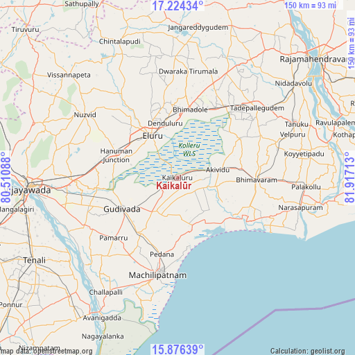
Kaikalūr GPS coordinates[2]
16° 33' 5.544" North, 81° 12' 50.4" East
| Map corner | latitude | longitude |
|---|---|---|
| Upper-left | 17.22434°, | 80.51088° |
| Center: | 16.55154°, | 81.214° |
| Lower-right: | 15.87639°, | 81.91713° |
| Map W x H: | 149.9×149.9 km | = 93.1×93.1mi |
| max Lat: | 34.9274° ⇑76.2% North |
| Kaikalūr: | 16.55154° |
| min Lat: | ⇓23.8% South 8.09008° |
| min Long | Kaikalūr | max Long |
| 68.82655° | 81.214° | 96.81° |
| W 73.7%⇐ | ⇒26.3% E |
Elevation
Elevation of Kaikalūr is 10 m = 33 ft, and this is 285.6 m = 937 ft below average elevation for this country.
| Max E: |
3681 m = 12077 ft | 96.4% |
| Avg. | 295.6 m = 970 ft | |
| Kaikalūr | 10 m = 33 ft | |
Min E: |
1 m = 3 ft | 3.6% |
See also: India elevation on elevation.city.
Geographical zone
Kaikalūr is located in North Torrid zone (between Equator and Tropic of Cancer). Distance of this Northern Tropic circle is 765.6 km =475.7 mi to North.| Distance of | km | miles | from Kaikalūr |
|---|---|---|---|
| North Pole | 8166.7 | 5074.6 | to North |
| Arctic Circle | 5560.8 | 3455.3 | to North |
| Tropic Cancer | 765.6 | 475.7 | to North |
| Equator | 1840.4 | 1143.6 | to South |


Nearby cities:
15 places around Kaikalūr: (largest is in red/bold)
• Akivīdu
18.1 km =11.2 mi,  79°
79°
• Attili
44.3 km =27.5 mi,  68°
68°
• Bhīmavaram
33 km =20.5 mi,  92°
92°
• Ellore
21.4 km =13.3 mi,  326°
326°
• Gannavaram
43.9 km =27.3 mi,  268°
268°
• Gudivāda
26.6 km =16.5 mi,  241°
241°
• Gudlavalleru
28.4 km =17.6 mi,  217°
217°
• Kanuru
29.9 km =18.6 mi,  171°
171°
• Korukollu
6.9 km =4.3 mi,  146°
146°
• Machilīpatnam
41.3 km =25.7 mi,  191°
191°
• Pallevāda
9.1 km =5.7 mi, 71°
• Pedana
33.7 km =20.9 mi, 192°
• Pippara
40.2 km =25 mi,  62°
62°
• Tādepallegūdem
44.4 km =27.6 mi,  48°
48°
• Vuyyūru
44.7 km =27.8 mi, 242°
Sources, notices
• [Note1] Compared only with cities in India existing in our database
• [Src1] Map data: © OpenStreetMap contributors (CC-BY-SA)
• [Src2] Other city data from geonames.org with taken over terms of usage.
• [Src3] Geographical zone / Annual Mean Temperature by Robert A. Rohde @ Wikipedia
