Pallevāda geodata
Pallevāda (Andhra Pradesh) is a populated place; located in India in Asia/Kolkata (GMT+5.5) time zone. With population of 2,955 people, there are 3416 cities with bigger population in this country. Compared to other cities in India, 76.1% of cities are located further ↑North; 74% of cities are located further ←West and 98.3% of cities have higher elevation than Pallevāda. Note1


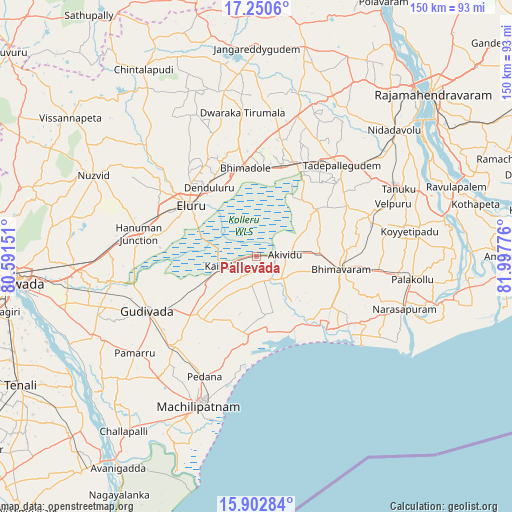
Pallevāda GPS coordinates[2]
16° 34' 40.44" North, 81° 17' 40.668" East
| Map corner | latitude | longitude |
|---|---|---|
| Upper-left | 17.2506°, | 80.59151° |
| Center: | 16.5779°, | 81.29463° |
| Lower-right: | 15.90284°, | 81.99776° |
| Map W x H: | 149.9×149.9 km | = 93.1×93.1mi |
| max Lat: | 34.9274° ⇑76.1% North |
| Pallevāda: | 16.5779° |
| min Lat: | ⇓23.9% South 8.09008° |
| min Long | Pallevāda | max Long |
| 68.82655° | 81.29463° | 96.81° |
| W 74%⇐ | ⇒26% E |
Elevation
Elevation of Pallevāda is 8 m = 26 ft, and this is 287.6 m = 944 ft below average elevation for this country.
| Max E: |
3681 m = 12077 ft | 98.3% |
| Avg. | 295.6 m = 970 ft | |
| Pallevāda | 8 m = 26 ft | |
Min E: |
1 m = 3 ft | 1.7% |
See also: India elevation on elevation.city.
Geographical zone
Pallevāda is located in North Torrid zone (between Equator and Tropic of Cancer). Distance of this Northern Tropic circle is 762.6 km =473.9 mi to North.| Distance of | km | miles | from Pallevāda |
|---|---|---|---|
| North Pole | 8163.8 | 5072.7 | to North |
| Arctic Circle | 5557.9 | 3453.5 | to North |
| Tropic Cancer | 762.6 | 473.9 | to North |
| Equator | 1843.3 | 1145.4 | to South |


Nearby cities:
15 places around Pallevāda: (largest is in red/bold)
• Akivīdu
9.2 km =5.7 mi,  86°
86°
• Attili
35.3 km =21.9 mi,  67°
67°
• Bhīmavaram
24.7 km =15.3 mi,  99°
99°
• Ellore
25.2 km =15.7 mi,  306°
306°
• Gudivāda
35.6 km =22.1 mi,  243°
243°
• Gudlavalleru
36.4 km =22.6 mi,  225°
225°
• Kaikalūr
9.1 km =5.7 mi,  251°
251°
• Kanuru
32.8 km =20.4 mi,  187°
187°
• Korukollu
9.9 km =6.2 mi,  208°
208°
• Machilīpatnam
46.5 km =28.9 mi,  200°
200°
• Narasapur
45.9 km =28.5 mi,  110°
110°
• Pedana
39.3 km =24.4 mi, 204°
• Pippara
31.3 km =19.4 mi,  60°
60°
• Tanuku
45.6 km =28.3 mi, 64°
• Tādepallegūdem
36.1 km =22.4 mi,  43°
43°
Sources, notices
• [Note1] Compared only with cities in India existing in our database
• [Src1] Map data: © OpenStreetMap contributors (CC-BY-SA)
• [Src2] Other city data from geonames.org with taken over terms of usage.
• [Src3] Geographical zone / Annual Mean Temperature by Robert A. Rohde @ Wikipedia
