Sūlūru geodata
Sūlūru (Andhra Pradesh) is a populated place; located in India in Asia/Kolkata (GMT+5.5) time zone. With population of 38,065 people, there are 1154 cities with bigger population in this country. Compared to other cities in India, 83.8% of cities are located further ↑North; 67.9% of cities are located further ←West and 96.4% of cities have higher elevation than Sūlūru. Note1


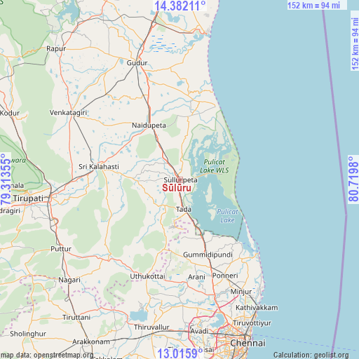
Sūlūru GPS coordinates[2]
13° 42' 0" North, 80° 1' 0.012" East
| Map corner | latitude | longitude |
|---|---|---|
| Upper-left | 14.38211°, | 79.31355° |
| Center: | 13.7°, | 80.01667° |
| Lower-right: | 13.0159°, | 80.7198° |
| Map W x H: | 151.9×151.9 km | = 94.4×94.4mi |
| max Lat: | 34.9274° ⇑83.8% North |
| Sūlūru: | 13.7° |
| min Lat: | ⇓16.2% South 8.09008° |
| min Long | Sūlūru | max Long |
| 68.82655° | 80.01667° | 96.81° |
| W 67.9%⇐ | ⇒32.1% E |
Elevation
Elevation of Sūlūru is 10 m = 33 ft, and this is 285.6 m = 937 ft below average elevation for this country.
| Max E: |
3681 m = 12077 ft | 96.4% |
| Avg. | 295.6 m = 970 ft | |
| Sūlūru | 10 m = 33 ft | |
Min E: |
1 m = 3 ft | 3.6% |
See also: India elevation on elevation.city.
Geographical zone
Sūlūru is located in North Torrid zone (between Equator and Tropic of Cancer). Distance of this Northern Tropic circle is 1082.6 km =672.7 mi to North.| Distance of | km | miles | from Sūlūru |
|---|---|---|---|
| North Pole | 8483.8 | 5271.6 | to North |
| Arctic Circle | 5877.9 | 3652.4 | to North |
| Tropic Cancer | 1082.6 | 672.7 | to North |
| Equator | 1523.3 | 946.5 | to South |


Nearby cities:
15 places around Sūlūru: (largest is in red/bold)
• Gummidipundi
34 km =21.1 mi,  162°
162°
• Gūdūr
53.2 km =33.1 mi,  340°
340°
• Kattivākkam
62.8 km =39 mi,  148°
148°
• Mīnjūr
53.6 km =33.3 mi, 150°
• Nagari
62.8 km =39 mi,  227°
227°
• Nāravārikuppam
59.4 km =36.9 mi, 162°
• Nārāyanavanam
55.4 km =34.4 mi,  236°
236°
• Nāyudupet
26.6 km =16.5 mi,  330°
330°
• Ponneri
44.6 km =27.7 mi, 154°
• Puduvāyal
43.4 km =27 mi, 161°
• Puttūr
57.7 km =35.9 mi, 240°
• Renigunta
54.7 km =34 mi,  264°
264°
• Tiruvallur
62.9 km =39.1 mi,  190°
190°
• Vellānūr
61 km =37.9 mi,  170°
170°
• Venkatagiri
55.3 km =34.4 mi,  301°
301°
Sources, notices
• [Note1] Compared only with cities in India existing in our database
• [Src1] Map data: © OpenStreetMap contributors (CC-BY-SA)
• [Src2] Other city data from geonames.org with taken over terms of usage.
• [Src3] Geographical zone / Annual Mean Temperature by Robert A. Rohde @ Wikipedia
