Gūdūr geodata
Gūdūr (Andhra Pradesh) is a populated place; located in India in Asia/Kolkata (GMT+5.5) time zone. With population of 74,851 people, there are 585 cities with bigger population in this country. Compared to other cities in India, 83% of cities are located further ↑North; 66.8% of cities are located further ←West and 90.4% of cities have higher elevation than Gūdūr. Note1


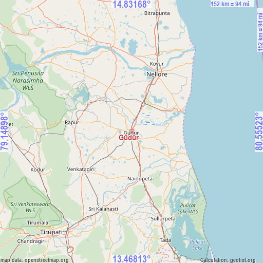
Gūdūr GPS coordinates[2]
14° 9' 3.348" North, 79° 51' 7.56" East
| Map corner | latitude | longitude |
|---|---|---|
| Upper-left | 14.83168°, | 79.14898° |
| Center: | 14.15093°, | 79.8521° |
| Lower-right: | 13.46813°, | 80.55523° |
| Map W x H: | 151.6×151.6 km | = 94.2×94.2mi |
| max Lat: | 34.9274° ⇑83% North |
| Gūdūr: | 14.15093° |
| min Lat: | ⇓17% South 8.09008° |
| min Long | Gūdūr | max Long |
| 68.82655° | 79.8521° | 96.81° |
| W 66.8%⇐ | ⇒33.2% E |
Elevation
Elevation of Gūdūr is 17 m = 56 ft, and this is 278.6 m = 914 ft below average elevation for this country.
| Max E: |
3681 m = 12077 ft | 90.4% |
| Avg. | 295.6 m = 970 ft | |
| Gūdūr | 17 m = 56 ft | |
Min E: |
1 m = 3 ft | 9.6% |
See also: Gūdūr elevation on elevation.city.
Geographical zone
Gūdūr is located in North Torrid zone (between Equator and Tropic of Cancer). Distance of this Northern Tropic circle is 1032.5 km =641.6 mi to North.| Distance of | km | miles | from Gūdūr |
|---|---|---|---|
| North Pole | 8433.6 | 5240.4 | to North |
| Arctic Circle | 5827.7 | 3621.2 | to North |
| Tropic Cancer | 1032.5 | 641.6 | to North |
| Equator | 1573.4 | 977.7 | to South |


Nearby cities:
15 places around Gūdūr: (largest is in red/bold)
• Akkarampalle
72.6 km =45.1 mi,  219°
219°
• Kovūr
41.4 km =25.7 mi,  20°
20°
• Narasingāpuram
83.6 km =51.9 mi, 223°
• Nellore
36.3 km =22.6 mi, 23°
• Nāgireddipalli
82 km =51 mi,  279°
279°
• Nārāyanavanam
85.5 km =53.1 mi,  199°
199°
• Nāyudupet
27.5 km =17.1 mi,  170°
170°
• Puttūr
85.2 km =52.9 mi, 202°
• Renigunta
66.5 km =41.3 mi,  213°
213°
• Rāzampeta
74.9 km =46.5 mi,  273°
273°
• Sūlūru
53.2 km =33.1 mi,  160°
160°
• Tirumala
75.1 km =46.7 mi,  226°
226°
• Tirupati
73.9 km =45.9 mi, 219°
• Vadlapūdi
18.5 km =11.5 mi,  343°
343°
• Venkatagiri
36.2 km =22.5 mi, 234°
Sources, notices
• [Note1] Compared only with cities in India existing in our database
• [Src1] Map data: © OpenStreetMap contributors (CC-BY-SA)
• [Src2] Other city data from geonames.org with taken over terms of usage.
• [Src3] Geographical zone / Annual Mean Temperature by Robert A. Rohde @ Wikipedia
