Sompeta geodata
Sompeta (Andhra Pradesh) is a populated place; located in India in Asia/Kolkata (GMT+5.5) time zone. With population of 17,982 people, there are 2202 cities with bigger population in this country. Compared to other cities in India, 68.8% of cities are located further ↑North; 83.3% of cities are located further ←West and 86.4% of cities have higher elevation than Sompeta. Note1


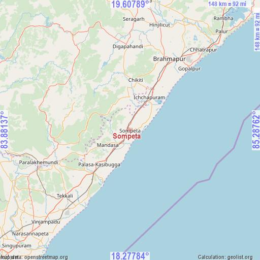
Sompeta GPS coordinates[2]
18° 56' 39.084" North, 84° 35' 4.164" East
| Map corner | latitude | longitude |
|---|---|---|
| Upper-left | 19.60789°, | 83.88137° |
| Center: | 18.94419°, | 84.58449° |
| Lower-right: | 18.27784°, | 85.28762° |
| Map W x H: | 147.9×147.9 km | = 91.9×91.9mi |
| max Lat: | 34.9274° ⇑68.8% North |
| Sompeta: | 18.94419° |
| min Lat: | ⇓31.2% South 8.09008° |
| min Long | Sompeta | max Long |
| 68.82655° | 84.58449° | 96.81° |
| W 83.3%⇐ | ⇒16.7% E |
Elevation
Elevation of Sompeta is 26 m = 85 ft, and this is 269.6 m = 885 ft below average elevation for this country.
| Max E: |
3681 m = 12077 ft | 86.4% |
| Avg. | 295.6 m = 970 ft | |
| Sompeta | 26 m = 85 ft | |
Min E: |
1 m = 3 ft | 13.6% |
See also: India elevation on elevation.city.
Geographical zone
Sompeta is located in North Torrid zone (between Equator and Tropic of Cancer). Distance of this Northern Tropic circle is 499.5 km =310.4 mi to North.| Distance of | km | miles | from Sompeta |
|---|---|---|---|
| North Pole | 7900.7 | 4909.3 | to North |
| Arctic Circle | 5294.8 | 3290 | to North |
| Tropic Cancer | 499.5 | 310.4 | to North |
| Equator | 2106.4 | 1308.9 | to South |


Nearby cities:
15 places around Sompeta: (largest is in red/bold)
• Brahmapur
46.3 km =28.8 mi,  28°
28°
• Chatrapur
62.1 km =38.6 mi,  42°
42°
• Chikitigarh
28.9 km =18 mi,  6°
6°
• Digapahandi
47.7 km =29.6 mi,  358°
358°
• Ganguvāda
58.1 km =36.1 mi,  237°
237°
• Ganjām
69.4 km =43.1 mi, 44°
• Gopālpur
48.6 km =30.2 mi, 43°
• Hinjilikatu
62.1 km =38.6 mi,  15°
15°
• Ichchāpuram
21.7 km =13.5 mi, 29°
• Mandasa
15.3 km =9.5 mi, 236°
• Palāsa
26.5 km =16.5 mi,  223°
223°
• Parlākimidi
55.3 km =34.4 mi,  250°
250°
• Purushottampur
71.4 km =44.4 mi, 26°
• Tekkali
52.6 km =32.7 mi, 224°
• Āsika
74.6 km =46.4 mi, 6°
Sources, notices
• [Note1] Compared only with cities in India existing in our database
• [Src1] Map data: © OpenStreetMap contributors (CC-BY-SA)
• [Src2] Other city data from geonames.org with taken over terms of usage.
• [Src3] Geographical zone / Annual Mean Temperature by Robert A. Rohde @ Wikipedia
