Ichchāpuram geodata
Ichchāpuram (Andhra Pradesh) is a populated place; located in India in Asia/Kolkata (GMT+5.5) time zone. With population of 33,754 people, there are 1288 cities with bigger population in this country. Compared to other cities in India, 68.2% of cities are located further ↑North; 83.5% of cities are located further ←West and 89.3% of cities have higher elevation than Ichchāpuram. Note1


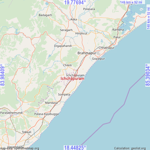
Ichchāpuram GPS coordinates[2]
19° 6' 50.148" North, 84° 41' 13.956" East
| Map corner | latitude | longitude |
|---|---|---|
| Upper-left | 19.77694°, | 83.98409° |
| Center: | 19.11393°, | 84.68721° |
| Lower-right: | 18.44825°, | 85.39034° |
| Map W x H: | 147.7×147.7 km | = 91.8×91.8mi |
| max Lat: | 34.9274° ⇑68.2% North |
| Ichchāpuram: | 19.11393° |
| min Lat: | ⇓31.8% South 8.09008° |
| min Long | Ichchāpuram | max Long |
| 68.82655° | 84.68721° | 96.81° |
| W 83.5%⇐ | ⇒16.5% E |
Elevation
Elevation of Ichchāpuram is 19 m = 62 ft, and this is 276.6 m = 907 ft below average elevation for this country.
| Max E: |
3681 m = 12077 ft | 89.3% |
| Avg. | 295.6 m = 970 ft | |
| Ichchāpuram | 19 m = 62 ft | |
Min E: |
1 m = 3 ft | 10.7% |
See also: India elevation on elevation.city.
Geographical zone
Ichchāpuram is located in North Torrid zone (between Equator and Tropic of Cancer). Distance of this Northern Tropic circle is 480.6 km =298.6 mi to North.| Distance of | km | miles | from Ichchāpuram |
|---|---|---|---|
| North Pole | 7881.8 | 4897.5 | to North |
| Arctic Circle | 5275.9 | 3278.3 | to North |
| Tropic Cancer | 480.6 | 298.6 | to North |
| Equator | 2125.3 | 1320.6 | to South |


Nearby cities:
15 places around Ichchāpuram: (largest is in red/bold)
• Brahmapur
24.6 km =15.3 mi,  26°
26°
• Chatrapur
41.1 km =25.5 mi,  49°
49°
• Chikitigarh
12.4 km =7.7 mi,  322°
322°
• Digapahandi
31.2 km =19.4 mi,  337°
337°
• Ganjām
48.8 km =30.3 mi, 51°
• Gopālpur
28 km =17.4 mi, 54°
• Hinjilikatu
41.3 km =25.7 mi,  8°
8°
• Kodala
62.7 km =39 mi, 25°
• Mandasa
36.1 km =22.4 mi,  220°
220°
• Palāsa
47.9 km =29.8 mi, 217°
• Polasara
65.8 km =40.9 mi, 11°
• Purushottampur
49.7 km =30.9 mi,  24°
24°
• Rambha
62.3 km =38.7 mi,  44°
44°
• Sompeta
21.7 km =13.5 mi,  209°
209°
• Āsika
55.4 km =34.4 mi,  357°
357°
Sources, notices
• [Note1] Compared only with cities in India existing in our database
• [Src1] Map data: © OpenStreetMap contributors (CC-BY-SA)
• [Src2] Other city data from geonames.org with taken over terms of usage.
• [Src3] Geographical zone / Annual Mean Temperature by Robert A. Rohde @ Wikipedia
