Brahmapur geodata
Brahmapur (Odisha) is a populated place; located in India in Asia/Kolkata (GMT+5.5) time zone. With population of 324,726 people, there are 134 cities with bigger population in this country. Compared to other cities in India, 67.5% of cities are located further ↑North; 83.8% of cities are located further ←West and 83% of cities have higher elevation than Brahmapur. Note1


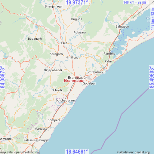
Brahmapur GPS coordinates[2]
19° 18' 41.436" North, 84° 47' 34.44" East
| Map corner | latitude | longitude |
|---|---|---|
| Upper-left | 19.97371°, | 84.08978° |
| Center: | 19.31151°, | 84.7929° |
| Lower-right: | 18.64661°, | 85.49603° |
| Map W x H: | 147.6×147.6 km | = 91.7×91.7mi |
| max Lat: | 34.9274° ⇑67.5% North |
| Brahmapur: | 19.31151° |
| min Lat: | ⇓32.5% South 8.09008° |
| min Long | Brahmapur | max Long |
| 68.82655° | 84.7929° | 96.81° |
| W 83.8%⇐ | ⇒16.2% E |
Elevation
Elevation of Brahmapur is 37 m = 121 ft, and this is 258.6 m = 848 ft below average elevation for this country.
| Max E: |
3681 m = 12077 ft | 83% |
| Avg. | 295.6 m = 970 ft | |
| Brahmapur | 37 m = 121 ft | |
Min E: |
1 m = 3 ft | 17% |
See also: Brahmapur elevation on elevation.city.
Geographical zone
Brahmapur is located in North Torrid zone (between Equator and Tropic of Cancer). Distance of this Northern Tropic circle is 458.7 km =285 mi to North.| Distance of | km | miles | from Brahmapur |
|---|---|---|---|
| North Pole | 7859.8 | 4883.9 | to North |
| Arctic Circle | 5253.9 | 3264.6 | to North |
| Tropic Cancer | 458.7 | 285 | to North |
| Equator | 2147.2 | 1334.2 | to South |


Nearby cities:
15 places around Brahmapur: (largest is in red/bold)
• Buguda
55.2 km =34.3 mi,  359°
359°
• Chatrapur
20.6 km =12.8 mi,  76°
76°
• Chikitigarh
22.3 km =13.9 mi,  237°
237°
• Digapahandi
24.2 km =15 mi,  286°
286°
• Ganjām
28.3 km =17.6 mi,  72°
72°
• Gopālpur
13.2 km =8.2 mi,  116°
116°
• Hinjilikatu
19.6 km =12.2 mi,  345°
345°
• Ichchāpuram
24.6 km =15.3 mi,  206°
206°
• Khallikot
45.2 km =28.1 mi,  42°
42°
• Kodala
38.1 km =23.7 mi,  24°
24°
• Polasara
42.6 km =26.5 mi,  2°
2°
• Purushottampur
25.1 km =15.6 mi, 22°
• Rambha
39.5 km =24.5 mi,  54°
54°
• Sompeta
46.3 km =28.8 mi, 208°
• Āsika
36.1 km =22.4 mi,  337°
337°
Sources, notices
• [Note1] Compared only with cities in India existing in our database
• [Src1] Map data: © OpenStreetMap contributors (CC-BY-SA)
• [Src2] Other city data from geonames.org with taken over terms of usage.
• [Src3] Geographical zone / Annual Mean Temperature by Robert A. Rohde @ Wikipedia
