Āsika geodata
Āsika (Odisha) is a populated place; located in India in Asia/Kolkata (GMT+5.5) time zone. With population of 21,134 people, there are 1958 cities with bigger population in this country. Compared to other cities in India, 66.7% of cities are located further ↑North; 83.4% of cities are located further ←West and 80.7% of cities have higher elevation than Āsika. Note1


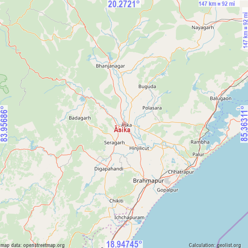
Āsika GPS coordinates[2]
19° 36' 40.104" North, 84° 39' 35.928" East
| Map corner | latitude | longitude |
|---|---|---|
| Upper-left | 20.2721°, | 83.95686° |
| Center: | 19.61114°, | 84.65998° |
| Lower-right: | 18.94745°, | 85.36311° |
| Map W x H: | 147.3×147.3 km | = 91.5×91.5mi |
| max Lat: | 34.9274° ⇑66.7% North |
| Āsika: | 19.61114° |
| min Lat: | ⇓33.3% South 8.09008° |
| min Long | Āsika | max Long |
| 68.82655° | 84.65998° | 96.81° |
| W 83.4%⇐ | ⇒16.6% E |
Elevation
Elevation of Āsika is 45 m = 148 ft, and this is 250.6 m = 822 ft below average elevation for this country.
| Max E: |
3681 m = 12077 ft | 80.7% |
| Avg. | 295.6 m = 970 ft | |
| Āsika | 45 m = 148 ft | |
Min E: |
1 m = 3 ft | 19.3% |
See also: India elevation on elevation.city.
Geographical zone
Āsika is located in North Torrid zone (between Equator and Tropic of Cancer). Distance of this Northern Tropic circle is 425.4 km =264.3 mi to North.| Distance of | km | miles | from Āsika |
|---|---|---|---|
| North Pole | 7826.5 | 4863.2 | to North |
| Arctic Circle | 5220.6 | 3243.9 | to North |
| Tropic Cancer | 425.4 | 264.3 | to North |
| Equator | 2180.6 | 1355 | to South |


Nearby cities:
15 places around Āsika: (largest is in red/bold)
• Belaguntha
30.3 km =18.8 mi,  355°
355°
• Bhanjanagar
36.1 km =22.4 mi,  346°
346°
• Brahmapur
36.1 km =22.4 mi,  157°
157°
• Buguda
25.8 km =16 mi,  32°
32°
• Chatrapur
44.2 km =27.5 mi,  129°
129°
• Chikitigarh
45.7 km =28.4 mi,  185°
185°
• Digapahandi
28.1 km =17.5 mi,  199°
199°
• Gopālpur
46.9 km =29.1 mi,  146°
146°
• Hinjilikatu
16.9 km =10.5 mi, 148°
• Khallikot
44.6 km =27.7 mi,  90°
90°
• Kodala
29.4 km =18.3 mi, 87°
• Polasara
18.6 km =11.6 mi,  60°
60°
• Purushottampur
25.7 km =16 mi,  113°
113°
• Rambha
47.3 km =29.4 mi,  102°
102°
• Sorada
29.3 km =18.2 mi,  304°
304°
Sources, notices
• [Note1] Compared only with cities in India existing in our database
• [Src1] Map data: © OpenStreetMap contributors (CC-BY-SA)
• [Src2] Other city data from geonames.org with taken over terms of usage.
• [Src3] Geographical zone / Annual Mean Temperature by Robert A. Rohde @ Wikipedia
