Sargūr geodata
Sargūr (Karnataka) is a populated place; located in India in Asia/Kolkata (GMT+5.5) time zone. With population of 10,983 people, there are 2833 cities with bigger population in this country. Compared to other cities in India, 89.8% of cities are located further ↑North; 69.2% of cities are located further →East and 92.3% of cities have lower elevation than Sargūr. Note1


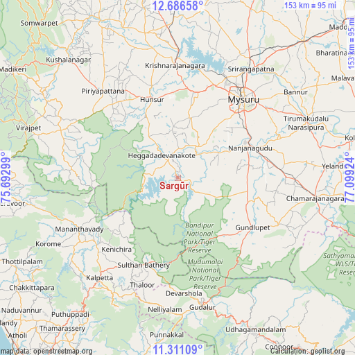
Sargūr GPS coordinates[2]
11° 59' 58.956" North, 76° 23' 45.996" East
| Map corner | latitude | longitude |
|---|---|---|
| Upper-left | 12.68658°, | 75.69299° |
| Center: | 11.99971°, | 76.39611° |
| Lower-right: | 11.31109°, | 77.09924° |
| Map W x H: | 152.9×152.9 km | = 95×95mi |
| max Lat: | 34.9274° ⇑89.8% North |
| Sargūr: | 11.99971° |
| min Lat: | ⇓10.2% South 8.09008° |
| min Long | Sargūr | max Long |
| 68.82655° | 76.39611° | 96.81° |
| W 30.8%⇐ | ⇒69.2% E |
Elevation
Elevation of Sargūr is 693 m = 2274 ft, and this is 397.4 m = 1304 ft above average elevation for this country.
| Max E: |
3681 m = 12077 ft | 7.7% |
| Sargūr | 693 m 2274 ft | |
| Avg. | 295.6 m = 970 ft | |
Min E: |
1 m = 3 ft | 92.3% |
See also: India elevation on elevation.city.
Geographical zone
Sargūr is located in North Torrid zone (between Equator and Tropic of Cancer). Distance of this Northern Tropic circle is 1271.7 km =790.2 mi to North.| Distance of | km | miles | from Sargūr |
|---|---|---|---|
| North Pole | 8672.8 | 5389 | to North |
| Arctic Circle | 6066.9 | 3769.8 | to North |
| Tropic Cancer | 1271.7 | 790.2 | to North |
| Equator | 1334.2 | 829 | to South |


Nearby cities:
15 places around Sargūr: (largest is in red/bold)
• Chamrajnagar
59.7 km =37.1 mi,  98°
98°
• Gundlupēt
38.3 km =23.8 mi,  123°
123°
• Heggadadevankote
12.2 km =7.6 mi,  323°
323°
• Hunsūr
35.6 km =22.1 mi,  341°
341°
• Kalpatta
55.2 km =34.3 mi,  218°
218°
• Masinigudi
54.9 km =34.1 mi,  150°
150°
• Mysore
42.4 km =26.3 mi,  38°
38°
• Naduvattam
59.9 km =37.2 mi,  164°
164°
• Nanjangūd
33.9 km =21.1 mi,  67°
67°
• Panamaram
45.4 km =28.2 mi,  230°
230°
• Perya
61.8 km =38.4 mi,  252°
252°
• Piriyāpatna
49.2 km =30.6 mi, 319°
• Ponnampet
51.6 km =32.1 mi,  288°
288°
• Shrīrangapattana
56.5 km =35.1 mi,  33°
33°
• Tirumakūdal Narsipur
59.8 km =37.2 mi, 66°
Sources, notices
• [Note1] Compared only with cities in India existing in our database
• [Src1] Map data: © OpenStreetMap contributors (CC-BY-SA)
• [Src2] Other city data from geonames.org with taken over terms of usage.
• [Src3] Geographical zone / Annual Mean Temperature by Robert A. Rohde @ Wikipedia
