Panamaram geodata
Panamaram (Kerala) is a populated place; located in India in Asia/Kolkata (GMT+5.5) time zone. With population of 11,651 people, there are 2769 cities with bigger population in this country. Compared to other cities in India, 90.5% of cities are located further ↑North; 72.8% of cities are located further →East and 92.6% of cities have lower elevation than Panamaram. Note1


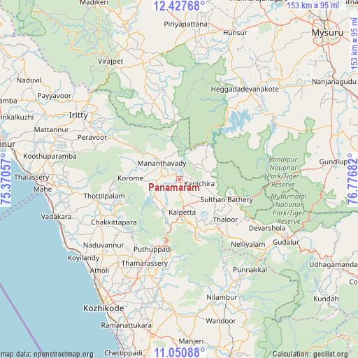
Panamaram GPS coordinates[2]
11° 44' 24.504" North, 76° 4' 25.284" East
| Map corner | latitude | longitude |
|---|---|---|
| Upper-left | 12.42768°, | 75.37057° |
| Center: | 11.74014°, | 76.07369° |
| Lower-right: | 11.05088°, | 76.77682° |
| Map W x H: | 153.1×153.1 km | = 95.1×95.1mi |
| max Lat: | 34.9274° ⇑90.5% North |
| Panamaram: | 11.74014° |
| min Lat: | ⇓9.5% South 8.09008° |
| min Long | Panamaram | max Long |
| 68.82655° | 76.07369° | 96.81° |
| W 27.2%⇐ | ⇒72.8% E |
Elevation
Elevation of Panamaram is 728 m = 2388 ft, and this is 432.4 m = 1419 ft above average elevation for this country.
| Max E: |
3681 m = 12077 ft | 7.4% |
| Panamaram | 728 m 2388 ft | |
| Avg. | 295.6 m = 970 ft | |
Min E: |
1 m = 3 ft | 92.6% |
See also: India elevation on elevation.city.
Geographical zone
Panamaram is located in North Torrid zone (between Equator and Tropic of Cancer). Distance of this Northern Tropic circle is 1300.5 km =808.1 mi to North.| Distance of | km | miles | from Panamaram |
|---|---|---|---|
| North Pole | 8701.7 | 5407 | to North |
| Arctic Circle | 6095.8 | 3787.8 | to North |
| Tropic Cancer | 1300.5 | 808.1 | to North |
| Equator | 1305.4 | 811.1 | to South |


Nearby cities:
15 places around Panamaram: (largest is in red/bold)
• Badagara
55.9 km =34.7 mi,  253°
253°
• Heggadadevankote
47.7 km =29.6 mi,  35°
35°
• Iringal
53.7 km =33.4 mi, 248°
• Kalpatta
14.7 km =9.1 mi,  175°
175°
• Kannavam
46.2 km =28.7 mi,  284°
284°
• Kunnamangalam
52.9 km =32.9 mi,  203°
203°
• Mattanur
58.6 km =36.4 mi,  291°
291°
• Mavoor
55.4 km =34.4 mi, 198°
• Naduvannūr
43 km =26.7 mi,  229°
229°
• Naduvattam
58.8 km =36.5 mi,  119°
119°
• Nādāpuram
46 km =28.6 mi,  262°
262°
• Perya
26.1 km =16.2 mi, 293°
• Ponnampet
47.1 km =29.3 mi,  342°
342°
• Sargūr
45.4 km =28.2 mi,  50°
50°
• Vīrarājendrapet
58.5 km =36.4 mi,  330°
330°
Sources, notices
• [Note1] Compared only with cities in India existing in our database
• [Src1] Map data: © OpenStreetMap contributors (CC-BY-SA)
• [Src2] Other city data from geonames.org with taken over terms of usage.
• [Src3] Geographical zone / Annual Mean Temperature by Robert A. Rohde @ Wikipedia
