Shrīrangapattana geodata
Shrīrangapattana (Karnataka) is a populated place; located in India in Asia/Kolkata (GMT+5.5) time zone. With population of 23,927 people, there are 1775 cities with bigger population in this country. Compared to other cities in India, 88.7% of cities are located further ↑North; 66.5% of cities are located further →East and 92.2% of cities have lower elevation than Shrīrangapattana. Note1


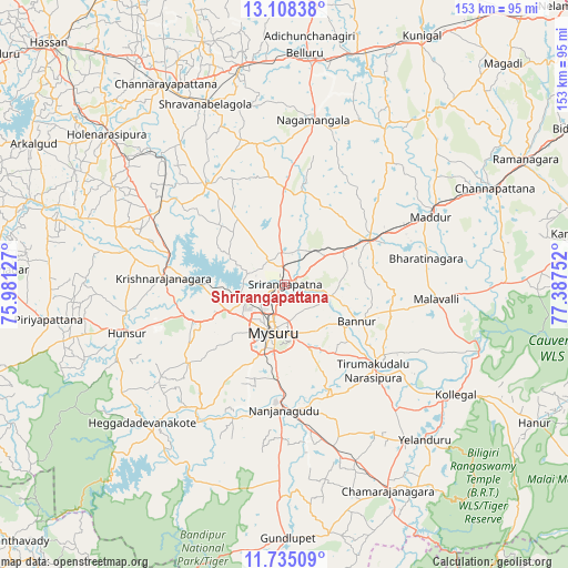
Shrīrangapattana GPS coordinates[2]
12° 25' 21.504" North, 76° 41' 3.804" East
| Map corner | latitude | longitude |
|---|---|---|
| Upper-left | 13.10838°, | 75.98127° |
| Center: | 12.42264°, | 76.68439° |
| Lower-right: | 11.73509°, | 77.38752° |
| Map W x H: | 152.7×152.7 km | = 94.9×94.9mi |
| max Lat: | 34.9274° ⇑88.7% North |
| Shrīrangapattana: | 12.42264° |
| min Lat: | ⇓11.3% South 8.09008° |
| min Long | Shrīrangapatta | max Long |
| 68.82655° | 76.68439° | 96.81° |
| W 33.5%⇐ | ⇒66.5% E |
Elevation
Elevation of Shrīrangapattana is 689 m = 2260 ft, and this is 393.4 m = 1291 ft above average elevation for this country.
| Max E: |
3681 m = 12077 ft | 7.8% |
| Shrīrangapattana | 689 m 2260 ft | |
| Avg. | 295.6 m = 970 ft | |
Min E: |
1 m = 3 ft | 92.2% |
See also: India elevation on elevation.city.
Geographical zone
Shrīrangapattana is located in North Torrid zone (between Equator and Tropic of Cancer). Distance of this Northern Tropic circle is 1224.7 km =761 mi to North.| Distance of | km | miles | from Shrīrangapattana |
|---|---|---|---|
| North Pole | 8625.8 | 5359.8 | to North |
| Arctic Circle | 6019.9 | 3740.6 | to North |
| Tropic Cancer | 1224.7 | 761 | to North |
| Equator | 1381.3 | 858.3 | to South |


Nearby cities:
15 places around Shrīrangapattana: (largest is in red/bold)
• Bannūr
21.7 km =13.5 mi,  117°
117°
• French Rocks
8.8 km =5.5 mi,  352°
352°
• Heggadadevankote
53.6 km =33.3 mi,  226°
226°
• Hunsūr
44.5 km =27.7 mi,  252°
252°
• Kollegāl
55.1 km =34.2 mi, 122°
• Krishnarājpet
34.5 km =21.4 mi,  321°
321°
• Maddūr
42.8 km =26.6 mi,  65°
65°
• Malavalli
41 km =25.5 mi,  95°
95°
• Mandya
25.6 km =15.9 mi,  64°
64°
• Melukote
27 km =16.8 mi, 351°
• Mysore
14.7 km =9.1 mi,  199°
199°
• Nanjangūd
33.9 km =21.1 mi,  180°
180°
• Nāgamangala
44.8 km =27.8 mi,  9°
9°
• Srāvana Belgola
52.8 km =32.8 mi,  336°
336°
• Tirumakūdal Narsipur
33.3 km =20.7 mi,  134°
134°
Sources, notices
• [Note1] Compared only with cities in India existing in our database
• [Src1] Map data: © OpenStreetMap contributors (CC-BY-SA)
• [Src2] Other city data from geonames.org with taken over terms of usage.
• [Src3] Geographical zone / Annual Mean Temperature by Robert A. Rohde @ Wikipedia
