Kalpatta geodata
Kalpatta (Kerala) is a populated place; located in India in Asia/Kolkata (GMT+5.5) time zone. With population of 29,602 people, there are 1468 cities with bigger population in this country. Compared to other cities in India, 90.9% of cities are located further ↑North; 72.7% of cities are located further →East and 93% of cities have lower elevation than Kalpatta. Note1


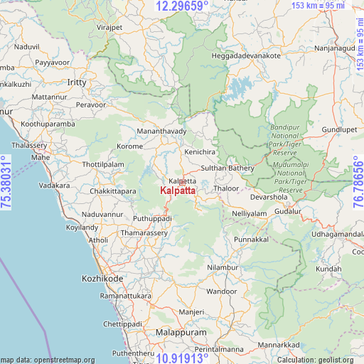
Kalpatta GPS coordinates[2]
11° 36' 31.356" North, 76° 5' 0.348" East
| Map corner | latitude | longitude |
|---|---|---|
| Upper-left | 12.29659°, | 75.38031° |
| Center: | 11.60871°, | 76.08343° |
| Lower-right: | 10.91913°, | 76.78656° |
| Map W x H: | 153.2×153.2 km | = 95.2×95.2mi |
| max Lat: | 34.9274° ⇑90.9% North |
| Kalpatta: | 11.60871° |
| min Lat: | ⇓9.1% South 8.09008° |
| min Long | Kalpatta | max Long |
| 68.82655° | 76.08343° | 96.81° |
| W 27.3%⇐ | ⇒72.7% E |
Elevation
Elevation of Kalpatta is 755 m = 2477 ft, and this is 459.4 m = 1507 ft above average elevation for this country.
| Max E: |
3681 m = 12077 ft | 7% |
| Kalpatta | 755 m 2477 ft | |
| Avg. | 295.6 m = 970 ft | |
Min E: |
1 m = 3 ft | 93% |
See also: India elevation on elevation.city.
Geographical zone
Kalpatta is located in North Torrid zone (between Equator and Tropic of Cancer). Distance of Equator is 1290.8 km =802.1 mi to South.| Distance of | km | miles | from Kalpatta |
|---|---|---|---|
| North Pole | 8716.3 | 5416.1 | to North |
| Arctic Circle | 6110.4 | 3796.8 | to North |
| Tropic Cancer | 1315.2 | 817.2 | to North |
| Equator | 1290.8 | 802.1 | to South |


Nearby cities:
15 places around Kalpatta: (largest is in red/bold)
• Badagara
54.7 km =34 mi,  268°
268°
• Beypore
57.2 km =35.5 mi,  211°
211°
• Ferokh
54.5 km =33.9 mi, 208°
• Iringal
51.1 km =31.8 mi,  263°
263°
• Kannavam
52.8 km =32.8 mi,  299°
299°
• Kozhikode
52 km =32.3 mi,  219°
219°
• Kunnamangalam
40.6 km =25.2 mi, 213°
• Manjeri
54.5 km =33.9 mi,  175°
175°
• Mavoor
42.2 km =26.2 mi, 205°
• Naduvannūr
36.2 km =22.5 mi,  248°
248°
• Naduvattam
52.1 km =32.4 mi,  105°
105°
• Nādāpuram
47.4 km =29.5 mi,  280°
280°
• Panamaram
14.7 km =9.1 mi,  355°
355°
• Perya
35.3 km =21.9 mi,  315°
315°
• Sargūr
55.2 km =34.3 mi,  38°
38°
Sources, notices
• [Note1] Compared only with cities in India existing in our database
• [Src1] Map data: © OpenStreetMap contributors (CC-BY-SA)
• [Src2] Other city data from geonames.org with taken over terms of usage.
• [Src3] Geographical zone / Annual Mean Temperature by Robert A. Rohde @ Wikipedia
