Gundlupēt geodata
Gundlupēt (Karnataka) is a populated place; located in India in Asia/Kolkata (GMT+5.5) time zone. With population of 27,197 people, there are 1577 cities with bigger population in this country. Compared to other cities in India, 90.2% of cities are located further ↑North; 66.4% of cities are located further →East and 94% of cities have lower elevation than Gundlupēt. Note1


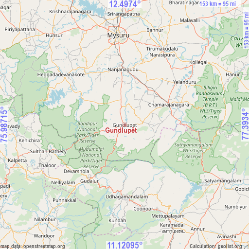
Gundlupēt GPS coordinates[2]
11° 48' 36.144" North, 76° 41' 24.972" East
| Map corner | latitude | longitude |
|---|---|---|
| Upper-left | 12.4974°, | 75.98715° |
| Center: | 11.81004°, | 76.69027° |
| Lower-right: | 11.12095°, | 77.3934° |
| Map W x H: | 153×153.1 km | = 95.1×95.1mi |
| max Lat: | 34.9274° ⇑90.2% North |
| Gundlupēt: | 11.81004° |
| min Lat: | ⇓9.8% South 8.09008° |
| min Long | Gundlupēt | max Long |
| 68.82655° | 76.69027° | 96.81° |
| W 33.6%⇐ | ⇒66.4% E |
Elevation
Elevation of Gundlupēt is 799 m = 2621 ft, and this is 503.4 m = 1652 ft above average elevation for this country.
| Max E: |
3681 m = 12077 ft | 6% |
| Gundlupēt | 799 m 2621 ft | |
| Avg. | 295.6 m = 970 ft | |
Min E: |
1 m = 3 ft | 94% |
See also: India elevation on elevation.city.
Geographical zone
Gundlupēt is located in North Torrid zone (between Equator and Tropic of Cancer). Distance of this Northern Tropic circle is 1292.8 km =803.3 mi to North.| Distance of | km | miles | from Gundlupēt |
|---|---|---|---|
| North Pole | 8693.9 | 5402.1 | to North |
| Arctic Circle | 6088 | 3782.9 | to North |
| Tropic Cancer | 1292.8 | 803.3 | to North |
| Equator | 1313.2 | 816 | to South |


Nearby cities:
15 places around Gundlupēt: (largest is in red/bold)
• Aruvankad
50.2 km =31.2 mi,  171°
171°
• Bannūr
61.1 km =38 mi,  17°
17°
• Chamrajnagar
29.9 km =18.6 mi,  65°
65°
• Heggadadevankote
50 km =31.1 mi,  308°
308°
• Kollegāl
59.6 km =37 mi,  50°
50°
• Kotagiri
47.1 km =29.3 mi,  156°
156°
• Masinigudi
27.4 km =17 mi,  191°
191°
• Mysore
54.5 km =33.9 mi,  354°
354°
• Naduvattam
39.9 km =24.8 mi,  203°
203°
• Nanjangūd
34.2 km =21.3 mi,  358°
358°
• Ooty
44.1 km =27.4 mi,  179°
179°
• Sargūr
38.3 km =23.8 mi,  303°
303°
• Tirumakūdal Narsipur
50.3 km =31.3 mi,  27°
27°
• Wellington
50.5 km =31.4 mi, 168°
• Yelandūr
45.4 km =28.2 mi, 54°
Sources, notices
• [Note1] Compared only with cities in India existing in our database
• [Src1] Map data: © OpenStreetMap contributors (CC-BY-SA)
• [Src2] Other city data from geonames.org with taken over terms of usage.
• [Src3] Geographical zone / Annual Mean Temperature by Robert A. Rohde @ Wikipedia
