Bhīmunipatnam geodata
Bhīmunipatnam (Andhra Pradesh) is a populated place; located in India in Asia/Kolkata (GMT+5.5) time zone. With population of 44,843 people, there are 989 cities with bigger population in this country. Compared to other cities in India, 72% of cities are located further ↑North; 80.6% of cities are located further ←West and 88.6% of cities have higher elevation than Bhīmunipatnam. Note1


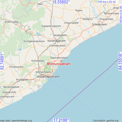
Bhīmunipatnam GPS coordinates[2]
17° 53' 24.612" North, 83° 27' 7.308" East
| Map corner | latitude | longitude |
|---|---|---|
| Upper-left | 18.55802°, | 82.74891° |
| Center: | 17.89017°, | 83.45203° |
| Lower-right: | 17.2198°, | 84.15516° |
| Map W x H: | 148.8×148.8 km | = 92.5×92.5mi |
| max Lat: | 34.9274° ⇑72% North |
| Bhīmunipatnam: | 17.89017° |
| min Lat: | ⇓28% South 8.09008° |
| min Long | Bhīmunipatnam | max Long |
| 68.82655° | 83.45203° | 96.81° |
| W 80.6%⇐ | ⇒19.4% E |
Elevation
Elevation of Bhīmunipatnam is 21 m = 69 ft, and this is 274.6 m = 901 ft below average elevation for this country.
| Max E: |
3681 m = 12077 ft | 88.6% |
| Avg. | 295.6 m = 970 ft | |
| Bhīmunipatnam | 21 m = 69 ft | |
Min E: |
1 m = 3 ft | 11.4% |
See also: Bhīmunipatnam elevation on elevation.city.
Geographical zone
Bhīmunipatnam is located in North Torrid zone (between Equator and Tropic of Cancer). Distance of this Northern Tropic circle is 616.7 km =383.2 mi to North.| Distance of | km | miles | from Bhīmunipatnam |
|---|---|---|---|
| North Pole | 8017.9 | 4982.1 | to North |
| Arctic Circle | 5412 | 3362.9 | to North |
| Tropic Cancer | 616.7 | 383.2 | to North |
| Equator | 1989.2 | 1236 | to South |


Nearby cities:
15 places around Bhīmunipatnam: (largest is in red/bold)
• Amudālavalasa
74.9 km =46.5 mi,  39°
39°
• Anakāpalle
52.3 km =32.5 mi,  245°
245°
• Bobbili
76.6 km =47.6 mi,  352°
352°
• Chodavaram
55.1 km =34.2 mi,  262°
262°
• Chīpurupalle
48.4 km =30.1 mi,  14°
14°
• Elamanchili
73.5 km =45.7 mi,  238°
238°
• Gajuwaka
32.7 km =20.3 mi,  229°
229°
• Mādugula
67.4 km =41.9 mi,  272°
272°
• Rāzām
65.9 km =40.9 mi,  19°
19°
• Srikakulam
65.4 km =40.6 mi,  46°
46°
• Sālūr
74.4 km =46.2 mi,  339°
339°
• Vepagunta
27.9 km =17.3 mi, 243°
• Visakhapatnam
35.3 km =21.9 mi, 228°
• Vizianagaram
25.6 km =15.9 mi, 350°
• Yārāda
31.9 km =19.8 mi,  216°
216°
Sources, notices
• [Note1] Compared only with cities in India existing in our database
• [Src1] Map data: © OpenStreetMap contributors (CC-BY-SA)
• [Src2] Other city data from geonames.org with taken over terms of usage.
• [Src3] Geographical zone / Annual Mean Temperature by Robert A. Rohde @ Wikipedia
