Kalamb geodata
Kalamb (Maharashtra) is a populated place; located in India in Asia/Kolkata (GMT+5.5) time zone. With population of 27,287 people, there are 1574 cities with bigger population in this country. Compared to other cities in India, 68.5% of cities are located further ↑North; 89.8% of cities are located further →East and 89.6% of cities have lower elevation than Kalamb. Note1


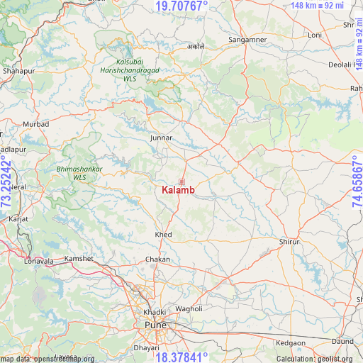
Kalamb GPS coordinates[2]
19° 2' 39.732" North, 73° 57' 19.944" East
| Map corner | latitude | longitude |
|---|---|---|
| Upper-left | 19.70767°, | 73.25242° |
| Center: | 19.04437°, | 73.95554° |
| Lower-right: | 18.37841°, | 74.65867° |
| Map W x H: | 147.8×147.8 km | = 91.8×91.8mi |
| max Lat: | 34.9274° ⇑68.5% North |
| Kalamb: | 19.04437° |
| min Lat: | ⇓31.5% South 8.09008° |
| min Long | Kalamb | max Long |
| 68.82655° | 73.95554° | 96.81° |
| W 10.2%⇐ | ⇒89.8% E |
Elevation
Elevation of Kalamb is 629 m = 2064 ft, and this is 333.4 m = 1094 ft above average elevation for this country.
| Max E: |
3681 m = 12077 ft | 10.4% |
| Kalamb | 629 m 2064 ft | |
| Avg. | 295.6 m = 970 ft | |
Min E: |
1 m = 3 ft | 89.6% |
See also: India elevation on elevation.city.
Geographical zone
Kalamb is located in North Torrid zone (between Equator and Tropic of Cancer). Distance of this Northern Tropic circle is 488.4 km =303.5 mi to North.| Distance of | km | miles | from Kalamb |
|---|---|---|---|
| North Pole | 7889.5 | 4902.3 | to North |
| Arctic Circle | 5283.6 | 3283.1 | to North |
| Tropic Cancer | 488.4 | 303.5 | to North |
| Equator | 2117.5 | 1315.8 | to South |


Nearby cities:
15 places around Kalamb: (largest is in red/bold)
• Alandi
41.2 km =25.6 mi,  188°
188°
• Chākan
33 km =20.5 mi,  197°
197°
• Dehu
41.3 km =25.7 mi,  208°
208°
• Junnar
20.1 km =12.5 mi,  335°
335°
• Khadki
54.6 km =33.9 mi, 191°
• Koregaon
45.6 km =28.3 mi,  166°
166°
• Lohogaon
49.6 km =30.8 mi,  183°
183°
• Manchar
4.6 km =2.9 mi, 195°
• Pimpri
49.4 km =30.7 mi, 198°
• Pune
59.3 km =36.8 mi, 190°
• Rājgurunagar
20.6 km =12.8 mi, 196°
• Shivaji Nagar
58.2 km =36.2 mi, 190°
• Sirūr
50.2 km =31.2 mi,  118°
118°
• Talegaon Dābhāde
45.3 km =28.1 mi,  220°
220°
• Wadgaon
47.5 km =29.5 mi, 224°
Sources, notices
• [Note1] Compared only with cities in India existing in our database
• [Src1] Map data: © OpenStreetMap contributors (CC-BY-SA)
• [Src2] Other city data from geonames.org with taken over terms of usage.
• [Src3] Geographical zone / Annual Mean Temperature by Robert A. Rohde @ Wikipedia
