Junnar geodata
Junnar (Maharashtra) is a populated place; located in India in Asia/Kolkata (GMT+5.5) time zone. With population of 25,997 people, there are 1637 cities with bigger population in this country. Compared to other cities in India, 67.9% of cities are located further ↑North; 90.5% of cities are located further →East and 92% of cities have lower elevation than Junnar. Note1


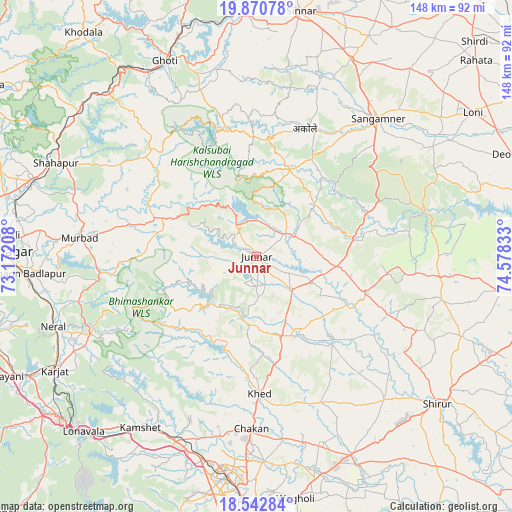
Junnar GPS coordinates[2]
19° 12' 29.34" North, 73° 52' 30.72" East
| Map corner | latitude | longitude |
|---|---|---|
| Upper-left | 19.87078°, | 73.17208° |
| Center: | 19.20815°, | 73.8752° |
| Lower-right: | 18.54284°, | 74.57833° |
| Map W x H: | 147.7×147.7 km | = 91.8×91.8mi |
| max Lat: | 34.9274° ⇑67.9% North |
| Junnar: | 19.20815° |
| min Lat: | ⇓32.1% South 8.09008° |
| min Long | Junnar | max Long |
| 68.82655° | 73.8752° | 96.81° |
| W 9.5%⇐ | ⇒90.5% E |
Elevation
Elevation of Junnar is 683 m = 2241 ft, and this is 387.4 m = 1271 ft above average elevation for this country.
| Max E: |
3681 m = 12077 ft | 8% |
| Junnar | 683 m 2241 ft | |
| Avg. | 295.6 m = 970 ft | |
Min E: |
1 m = 3 ft | 92% |
See also: India elevation on elevation.city.
Geographical zone
Junnar is located in North Torrid zone (between Equator and Tropic of Cancer). Distance of this Northern Tropic circle is 470.2 km =292.2 mi to North.| Distance of | km | miles | from Junnar |
|---|---|---|---|
| North Pole | 7871.3 | 4891 | to North |
| Arctic Circle | 5265.4 | 3271.8 | to North |
| Tropic Cancer | 470.2 | 292.2 | to North |
| Equator | 2135.7 | 1327.1 | to South |


Nearby cities:
15 places around Junnar: (largest is in red/bold)
• Alandi
59 km =36.7 mi,  177°
177°
• Badlapur
64.3 km =40 mi,  264°
264°
• Chākan
49.8 km =30.9 mi, 181°
• Dehu
55.6 km =34.5 mi,  191°
191°
• Ghoti Budrukh
62.2 km =38.6 mi,  335°
335°
• Igatpuri
63.3 km =39.3 mi,  328°
328°
• Kalamb
20.1 km =12.5 mi,  155°
155°
• Manchar
23.8 km =14.8 mi, 162°
• Murbād
51.2 km =31.8 mi,  275°
275°
• Neral
62.1 km =38.6 mi,  250°
250°
• Rājgurunagar
38.1 km =23.7 mi, 176°
• Sangamner
53.3 km =33.1 mi,  41°
41°
• Shāhāpur
63.7 km =39.6 mi,  295°
295°
• Talegaon Dābhāde
56.6 km =35.2 mi,  201°
201°
• Wadgaon
57.7 km =35.9 mi,  205°
205°
Sources, notices
• [Note1] Compared only with cities in India existing in our database
• [Src1] Map data: © OpenStreetMap contributors (CC-BY-SA)
• [Src2] Other city data from geonames.org with taken over terms of usage.
• [Src3] Geographical zone / Annual Mean Temperature by Robert A. Rohde @ Wikipedia
