Puruliya geodata
Puruliya (West Bengal) is a populated place; located in India in Asia/Kolkata (GMT+5.5) time zone. With population of 122,533 people, there are 358 cities with bigger population in this country. Compared to other cities in India, 53.8% of cities are located further ↓South; 87.8% of cities are located further ←West and 60.5% of cities have lower elevation than Puruliya. Note1


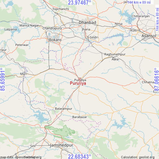
Puruliya GPS coordinates[2]
23° 19' 50.232" North, 86° 21' 46.908" East
| Map corner | latitude | longitude |
|---|---|---|
| Upper-left | 23.97467°, | 85.65991° |
| Center: | 23.33062°, | 86.36303° |
| Lower-right: | 22.68343°, | 87.06616° |
| Map W x H: | 143.6×143.6 km | = 89.2×89.2mi |
| max Lat: | 34.9274° ⇑46.2% North |
| Puruliya: | 23.33062° |
| min Lat: | ⇓53.8% South 8.09008° |
| min Long | Puruliya | max Long |
| 68.82655° | 86.36303° | 96.81° |
| W 87.8%⇐ | ⇒12.2% E |
Elevation
Elevation of Puruliya is 255 m = 837 ft, and this is 40.6 m = 133 ft below average elevation for this country.
| Max E: |
3681 m = 12077 ft | 39.5% |
| Avg. | 295.6 m = 970 ft | |
| Puruliya | 255 m = 837 ft | |
Min E: |
1 m = 3 ft | 60.5% |
See also: Puruliya elevation on elevation.city.
Geographical zone
Puruliya is located in North Torrid zone (between Equator and Tropic of Cancer). Distance of this Northern Tropic circle is 11.8 km =7.3 mi to North.| Distance of | km | miles | from Puruliya |
|---|---|---|---|
| North Pole | 7412.9 | 4606.2 | to North |
| Arctic Circle | 4807.1 | 2987 | to North |
| Tropic Cancer | 11.8 | 7.3 | to North |
| Equator | 2594.1 | 1611.9 | to South |


Nearby cities:
15 places around Puruliya: (largest is in red/bold)
• Adra
37.6 km =23.4 mi,  60°
60°
• Bagra
45 km =28 mi,  353°
353°
• Balarāmpur
29.6 km =18.4 mi,  208°
208°
• Bhojudih
35.3 km =21.9 mi,  13°
13°
• Chās
39.4 km =24.5 mi,  329°
329°
• Dugda
50 km =31.1 mi,  337°
337°
• Jhalidā
39.7 km =24.7 mi,  275°
275°
• Jharia
45.9 km =28.5 mi, 6°
• Jāmadoba
43.1 km =26.8 mi, 5°
• Kenda
21.6 km =13.4 mi,  133°
133°
• Kenduadīh
49.5 km =30.8 mi,  1°
1°
• Lakhyabad
48.5 km =30.1 mi,  39°
39°
• Pāthardih
37.9 km =23.5 mi, 10°
• Raghunathpur
39.2 km =24.4 mi,  53°
53°
• Sijua
49.7 km =30.9 mi,  356°
356°
Sources, notices
• [Note1] Compared only with cities in India existing in our database
• [Src1] Map data: © OpenStreetMap contributors (CC-BY-SA)
• [Src2] Other city data from geonames.org with taken over terms of usage.
• [Src3] Geographical zone / Annual Mean Temperature by Robert A. Rohde @ Wikipedia
