Lakhyabad geodata
Lakhyabad (West Bengal) is a populated place; located in India in Asia/Kolkata (GMT+5.5) time zone. With population of 33,162 people, there are 1313 cities with bigger population in this country. Compared to other cities in India, 55.9% of cities are located further ↓South; 88.6% of cities are located further ←West and 61.1% of cities have higher elevation than Lakhyabad. Note1


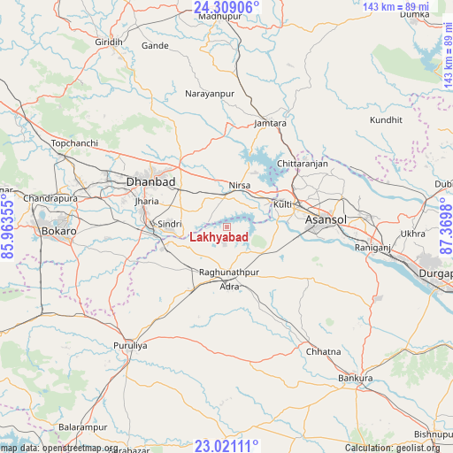
Lakhyabad GPS coordinates[2]
23° 40' 0.012" North, 86° 40' 0.012" East
| Map corner | latitude | longitude |
|---|---|---|
| Upper-left | 24.30906°, | 85.96355° |
| Center: | 23.66667°, | 86.66667° |
| Lower-right: | 23.02111°, | 87.3698° |
| Map W x H: | 143.2×143.2 km | = 89×89mi |
| max Lat: | 34.9274° ⇑44.1% North |
| Lakhyabad: | 23.66667° |
| min Lat: | ⇓55.9% South 8.09008° |
| min Long | Lakhyabad | max Long |
| 68.82655° | 86.66667° | 96.81° |
| W 88.6%⇐ | ⇒11.4% E |
Elevation
Elevation of Lakhyabad is 142 m = 466 ft, and this is 153.6 m = 504 ft below average elevation for this country.
| Max E: |
3681 m = 12077 ft | 61.1% |
| Avg. | 295.6 m = 970 ft | |
| Lakhyabad | 142 m = 466 ft | |
Min E: |
1 m = 3 ft | 38.9% |
See also: India elevation on elevation.city.
Geographical zone
Lakhyabad is located in North temperate zone (between Tropic of Cancer and the Arctic Circle). Distance of this Northern Tropic circle is 25.6 km =15.9 mi to South.| Distance of | km | miles | from Lakhyabad |
|---|---|---|---|
| North Pole | 7375.6 | 4583 | to North |
| Arctic Circle | 4769.7 | 2963.8 | to North |
| Tropic Cancer | 25.6 | 15.9 | to South |
| Equator | 2631.5 | 1635.1 | to South |


Nearby cities:
15 places around Lakhyabad: (largest is in red/bold)
• Adra
19 km =11.8 mi,  174°
174°
• Bhojudih
23.2 km =14.4 mi,  262°
262°
• Chittaranjan
32 km =19.9 mi,  48°
48°
• Dhanbād
27.3 km =17 mi,  303°
303°
• Gobindpur
24.1 km =15 mi,  321°
321°
• Jharia
27 km =16.8 mi,  287°
287°
• Jāmadoba
27.7 km =17.2 mi,  281°
281°
• Jāmtāra
35.7 km =22.2 mi,  22°
22°
• Kenduadīh
32 km =19.9 mi, 292°
• Kulti
19.4 km =12.1 mi,  68°
68°
• Mugma
13.1 km =8.1 mi,  28°
28°
• Nirsā
13.7 km =8.5 mi, 17°
• Pāthardih
23.9 km =14.9 mi,  269°
269°
• Raghunathpur
14.2 km =8.8 mi,  177°
177°
• Āsansol
32.3 km =20.1 mi,  86°
86°
Sources, notices
• [Note1] Compared only with cities in India existing in our database
• [Src1] Map data: © OpenStreetMap contributors (CC-BY-SA)
• [Src2] Other city data from geonames.org with taken over terms of usage.
• [Src3] Geographical zone / Annual Mean Temperature by Robert A. Rohde @ Wikipedia
