Pudukkottai geodata
Pudukkottai (Tamil Nadu) is a populated place; located in India in Asia/Kolkata (GMT+5.5) time zone. With population of 112,118 people, there are 394 cities with bigger population in this country. Compared to other cities in India, 95.3% of cities are located further ↑North; 57.2% of cities are located further ←West and 68.1% of cities have higher elevation than Pudukkottai. Note1


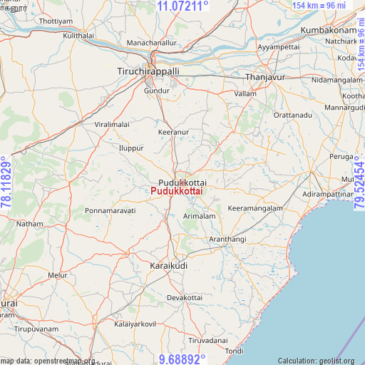
Pudukkottai GPS coordinates[2]
10° 22' 52.608" North, 78° 49' 17.076" East
| Map corner | latitude | longitude |
|---|---|---|
| Upper-left | 11.07211°, | 78.11829° |
| Center: | 10.38128°, | 78.82141° |
| Lower-right: | 9.68892°, | 79.52454° |
| Map W x H: | 153.8×153.8 km | = 95.6×95.6mi |
| max Lat: | 34.9274° ⇑95.3% North |
| Pudukkottai: | 10.38128° |
| min Lat: | ⇓4.7% South 8.09008° |
| min Long | Pudukkottai | max Long |
| 68.82655° | 78.82141° | 96.81° |
| W 57.2%⇐ | ⇒42.8% E |
Elevation
Elevation of Pudukkottai is 102 m = 335 ft, and this is 193.6 m = 635 ft below average elevation for this country.
| Max E: |
3681 m = 12077 ft | 68.1% |
| Avg. | 295.6 m = 970 ft | |
| Pudukkottai | 102 m = 335 ft | |
Min E: |
1 m = 3 ft | 31.9% |
See also: Pudukkottai elevation on elevation.city.
Geographical zone
Pudukkottai is located in North Torrid zone (between Equator and Tropic of Cancer). Distance of Equator is 1154.3 km =717.2 mi to South.| Distance of | km | miles | from Pudukkottai |
|---|---|---|---|
| North Pole | 8852.8 | 5500.9 | to North |
| Arctic Circle | 6246.9 | 3881.6 | to North |
| Tropic Cancer | 1451.6 | 902 | to North |
| Equator | 1154.3 | 717.2 | to South |


Nearby cities:
15 places around Pudukkottai: (largest is in red/bold)
• Annavāsal
15.9 km =9.9 mi,  303°
303°
• Arantāngi
29.7 km =18.5 mi,  141°
141°
• Arimalam
15.6 km =9.7 mi,  153°
153°
• Iluppūr
26.2 km =16.3 mi, 304°
• Kanadukattan
23.7 km =14.7 mi,  191°
191°
• Karambakkudi
36 km =22.4 mi,  76°
76°
• Kottaiyūr
30.3 km =18.8 mi, 185°
• Kāraikkudi
35.5 km =22.1 mi, 189°
• Kīranūr
21.3 km =13.2 mi,  349°
349°
• Pallattūr
26.2 km =16.3 mi,  184°
184°
• Peravurani
42.8 km =26.6 mi,  103°
103°
• Ponnamarāvati
33.2 km =20.6 mi,  250°
250°
• Puliyūr
28.2 km =17.5 mi,  4°
4°
• Vallam
45.8 km =28.5 mi,  34°
34°
• Ālangudi
18 km =11.2 mi, 97°
Sources, notices
• [Note1] Compared only with cities in India existing in our database
• [Src1] Map data: © OpenStreetMap contributors (CC-BY-SA)
• [Src2] Other city data from geonames.org with taken over terms of usage.
• [Src3] Geographical zone / Annual Mean Temperature by Robert A. Rohde @ Wikipedia
