Peravurani geodata
Peravurani (Tamil Nadu) is a populated place; located in India in Asia/Kolkata (GMT+5.5) time zone. With population of 21,663 people, there are 1923 cities with bigger population in this country. Compared to other cities in India, 95.6% of cities are located further ↑North; 61% of cities are located further ←West and 85.5% of cities have higher elevation than Peravurani. Note1


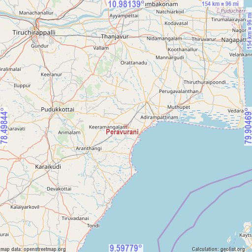
Peravurani GPS coordinates[2]
10° 17' 25.26" North, 79° 12' 5.616" East
| Map corner | latitude | longitude |
|---|---|---|
| Upper-left | 10.98139°, | 78.49844° |
| Center: | 10.29035°, | 79.20156° |
| Lower-right: | 9.59779°, | 79.90469° |
| Map W x H: | 153.8×153.8 km | = 95.6×95.6mi |
| max Lat: | 34.9274° ⇑95.6% North |
| Peravurani: | 10.29035° |
| min Lat: | ⇓4.4% South 8.09008° |
| min Long | Peravurani | max Long |
| 68.82655° | 79.20156° | 96.81° |
| W 61%⇐ | ⇒39% E |
Elevation
Elevation of Peravurani is 29 m = 95 ft, and this is 266.6 m = 875 ft below average elevation for this country.
| Max E: |
3681 m = 12077 ft | 85.5% |
| Avg. | 295.6 m = 970 ft | |
| Peravurani | 29 m = 95 ft | |
Min E: |
1 m = 3 ft | 14.5% |
See also: India elevation on elevation.city.
Geographical zone
Peravurani is located in North Torrid zone (between Equator and Tropic of Cancer). Distance of Equator is 1144.2 km =711 mi to South.| Distance of | km | miles | from Peravurani |
|---|---|---|---|
| North Pole | 8862.9 | 5507.1 | to North |
| Arctic Circle | 6257 | 3887.9 | to North |
| Tropic Cancer | 1461.7 | 908.3 | to North |
| Equator | 1144.2 | 711 | to South |


Nearby cities:
15 places around Peravurani: (largest is in red/bold)
• Adirampattinam
20.2 km =12.6 mi,  73°
73°
• Arantāngi
26.5 km =16.5 mi,  240°
240°
• Arimalam
35 km =21.7 mi,  263°
263°
• Kanadukattan
48 km =29.8 mi,  254°
254°
• Karambakkudi
19.9 km =12.4 mi,  340°
340°
• Kottaiyūr
48.8 km =30.3 mi, 245°
• Kāraikkudi
53.6 km =33.3 mi, 242°
• Madukkūr
30.3 km =18.8 mi,  45°
45°
• Mannargudi
49.9 km =31 mi,  33°
33°
• Muttupet
34 km =21.1 mi, 69°
• Pallattūr
46.5 km =28.9 mi, 249°
• Pattukkottai
19.6 km =12.2 mi,  41°
41°
• Pudukkottai
42.8 km =26.6 mi,  283°
283°
• Vallam
50.2 km =31.2 mi, 342°
• Ālangudi
25 km =15.5 mi,  288°
288°
Sources, notices
• [Note1] Compared only with cities in India existing in our database
• [Src1] Map data: © OpenStreetMap contributors (CC-BY-SA)
• [Src2] Other city data from geonames.org with taken over terms of usage.
• [Src3] Geographical zone / Annual Mean Temperature by Robert A. Rohde @ Wikipedia
