Pallattūr geodata
Pallattūr (Tamil Nadu) is a populated place; located in India in Asia/Kolkata (GMT+5.5) time zone. With population of 8,186 people, there are 3111 cities with bigger population in this country. Compared to other cities in India, 96% of cities are located further ↑North; 57% of cities are located further ←West and 67.4% of cities have higher elevation than Pallattūr. Note1


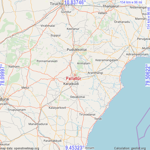
Pallattūr GPS coordinates[2]
10° 8' 45.924" North, 78° 48' 11.124" East
| Map corner | latitude | longitude |
|---|---|---|
| Upper-left | 10.83746°, | 78.09997° |
| Center: | 10.14609°, | 78.80309° |
| Lower-right: | 9.45323°, | 79.50622° |
| Map W x H: | 153.9×153.9 km | = 95.6×95.6mi |
| max Lat: | 34.9274° ⇑96% North |
| Pallattūr: | 10.14609° |
| min Lat: | ⇓4% South 8.09008° |
| min Long | Pallattūr | max Long |
| 68.82655° | 78.80309° | 96.81° |
| W 57%⇐ | ⇒43% E |
Elevation
Elevation of Pallattūr is 105 m = 344 ft, and this is 190.6 m = 625 ft below average elevation for this country.
| Max E: |
3681 m = 12077 ft | 67.4% |
| Avg. | 295.6 m = 970 ft | |
| Pallattūr | 105 m = 344 ft | |
Min E: |
1 m = 3 ft | 32.6% |
See also: India elevation on elevation.city.
Geographical zone
Pallattūr is located in North Torrid zone (between Equator and Tropic of Cancer). Distance of Equator is 1128.1 km =701 mi to South.| Distance of | km | miles | from Pallattūr |
|---|---|---|---|
| North Pole | 8878.9 | 5517.1 | to North |
| Arctic Circle | 6273 | 3897.9 | to North |
| Tropic Cancer | 1477.8 | 918.3 | to North |
| Equator | 1128.1 | 701 | to South |


Nearby cities:
15 places around Pallattūr: (largest is in red/bold)
• Annavāsal
36.7 km =22.8 mi,  342°
342°
• Arantāngi
20.8 km =12.9 mi,  81°
81°
• Arimalam
15 km =9.3 mi,  36°
36°
• Devakottai
22.2 km =13.8 mi,  174°
174°
• Iluppūr
45.3 km =28.1 mi,  334°
334°
• Kanadukattan
3.9 km =2.4 mi,  318°
318°
• Kottaiyūr
4.1 km =2.5 mi,  191°
191°
• Kāraikkudi
9.7 km =6 mi,  203°
203°
• Kīranūr
47.2 km =29.3 mi,  357°
357°
• Mangalam
46 km =28.6 mi, 202°
• Nāttarasankottai
41.2 km =25.6 mi,  221°
221°
• Peravurani
46.5 km =28.9 mi,  69°
69°
• Ponnamarāvati
32.8 km =20.4 mi,  297°
297°
• Pudukkottai
26.2 km =16.3 mi,  4°
4°
• Ālangudi
31.1 km =19.3 mi, 39°
Sources, notices
• [Note1] Compared only with cities in India existing in our database
• [Src1] Map data: © OpenStreetMap contributors (CC-BY-SA)
• [Src2] Other city data from geonames.org with taken over terms of usage.
• [Src3] Geographical zone / Annual Mean Temperature by Robert A. Rohde @ Wikipedia
